Joe Carver Rd to Liberty Church Rd
Linked via: Nhdplus created 95% confidence Synced 6mo ago
Gauge Conditions
Runnable: 150.0 – 750.0 CFS
Data from American Whitewater & USGS
Run Map
Run Time Estimate
Select put-in and take-out to estimate time.
Unlock Advanced Trip Planning
See wind-adjusted speed maps, forecast planning, and detailed time estimates.
Sign in to generate an AI timing estimate for this run.
Whitewater timing varies with scouting, portages, and group pace. Use as a planning baseline.
Description
The best part of this run is the section from the "gravel pit" (on Cove Creek Rd just downstream from where Cove Creek Rdintersects with Jonathan Creek Rd / US 276) to the takeout near / at Liberty Church Rd. A common alternate put-in is at the Fire Station on Joe Carver Rd; the folks at the Fire Station have been friendly and gracious but ask before you park there. This upper put-in adds another 3 miles to the lower section but the quality is not as good. You could also put in further upstream at Grindstone or Hemphill roads but the author has not done so and sees no purpose in doing so.
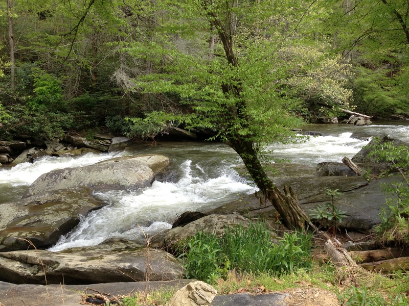
The first 3 miles from the fire station are continuous class 1+ to 2- with a lot of standing waves. There are only a couple spots where there are distinct rapids. You will be paddling mostly through farmer's field but also past sawmills, industrial facilities, a trailer park and a very well maintained and landscaped RV park. As you pass under Jonathan Creek Rd / rte 276 the second time you will pass the "gravel pit' and enter a nicer section of the creek. The banks become steeper and more wooded and a few distinct rapids and easy places to surf appear. Most of the homes along this stretch are expensive, well landscaped and not terribly intrusive.
Not far after passing Gold Finch Way (bridge with metal protector on the center piling) you will encounter Double Drop, the first truly distinct rapid. The first part is a sloping tongue, the second drop has a hole. Small rapids continue until after you pass under I-40 and two smaller bridges. You will notice that the price / quality of the homes drops a bit. One enterprising home owner has used several vehicle chassis as a bank stabilizer rather than the normal techniques of rip-rap or gabions. About a hundred yards after this "marker" the real action starts. The river turns to the right (and there is a good sandy takeout eddy on the left ) then back to the left (where there is a tighter last chance eddy) above the meat of the run.
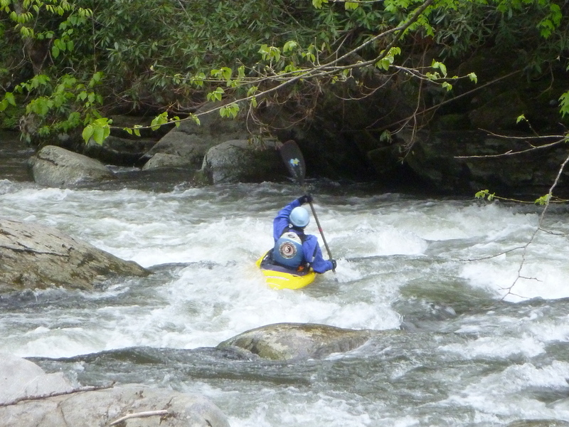
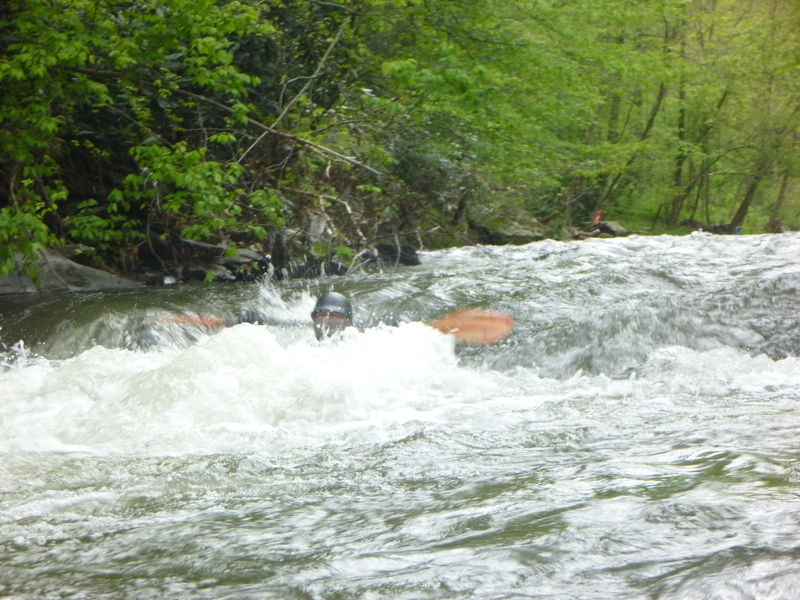
There are two class 3 rapids each has a small lead-in drop of about 2 ft. Most boaters should look at these two drops before running them. ( A good time to do this is when setting shuttle) There are inviting looking chutes on the left which neck down to a point too narrow to fit a boat through. The first, Submarine, can be run by taking a right side chute on the entry drop which lines you up for the 8-10 ft. wide right side of the main drop. This 8-10 ft wide slot can be run on the left or right (or center if you wish to practice your roll). The author prefers left with a little left angle.
The second rapid, Wendy's Wonder, has a similar entry drop on the right which also lines you up for the main drop. This main drop can be run in the center of the right chute with a little right bow angle to help you partially "square up" to punch the diagonal wave near the top. The next rapid is Shoulder Bone (boat scoutable). There are takeouts below Wendy'd Wonder and Shoulder Bone which do not involve steep banks. The remainder to the bridge is boat scoutable and there are plenty of chutes and eddies. . If you paddle to the bridge the takeout is on river left, just below the bridge, but it's fairly steep so bring a rope. Most people get out at the upper easier takeouts.
Be careful where you park at the takeout as some of the local people are protective about their property. There are about 3 parking spots above the bridge along White Oak Rd at the Liberty Church bridge and another 3 below. The land where you could scout the steep section with Submarine and Wendy's Wonder is now posted "no trespassing"
At the upper end of the flow range The rapids near the end transition to 3+, then class 4. It can be run above 750 on the Cataloochee Cr gauge by people who don't need advice from me.
I'll leave the original post below up for a while. As of 2013 there was a little wood above the gravel pit (avoidable at most water levels) and everything below was clear. It is however a small, relatively narrow creek so always be alert for wood, especially after a storm. The former USGS gauge was located near submarine but is no more.
Carolina Whitewater, B.Benner
Dave Schall testified:
From the put-in at Rt. 1394 to US276, the river is fairly Nantahalaesque with long and fairly continuous shoals. There is one class III chute with wood completely blocking the left channel. Run it on the right but look out for wood. It looks like a beaver dam gone mad. There is more wood further down and one river wide strainer that requires a portage on the left. The river continues at a class II pace with a few small play waves until it crosses under the US276 bridge.
After the bridge, the river turns 'creeky' and picks up a bit with a few class III ledge drops. This might be a better put-in as the upper section was kind of uneventful. There are a few hazards in this section to be aware of. There was a single strand of barbed wire strung at eyeball level that requires careful attention. It was in the middle of a pretty swift class II shoal. We cut it but it may have reappeared since.
One of the drops in this section requires very serious attention, not because of its difficulty, but rather its potential for badness in case of a screw-up. There is a very narrow slot on the left that is packed full of wood. A good portion of the current goes towards and then under this debris dam. The line requires a drop off a 2' ledge and then a quick turn to the right through the open slot. Overturning here would be the equivalent of dropping into a spaghetti strainer with a whole lot of boiling water pushing on you. The drop is pretty obvious and there is plenty of time to eddy out above it. Scout or portage on the left. The take-out shortly after on river left.
There is room for parking at the USGS gauge, White Oak Rd. It is possible to paddle down further and walk back up the gravel road (the first on the right after the USGS gauge, Rabbit Run Rd maybe?). There is a great play hole at the end of the gravel road. I wouldn't park down there though because it is essentially someone's backyard.
Speaking of backyards - Jonathans Creek runs through every backyard and dog lot in Maggie Valley. In places the river banks resemble a junk yard, and not just because of the 2-liter bottles and milk jugs. Entire automobiles have been placed as retaining walls to stop stream erosion. In short, it's hideous. For what it's worth, the water quality didn't seem too bad. Runnable when other stuff is too high. Benner and Benner say 1.5'+ on the Jonathans Creek USGS gauge is good to go.
Later, Dave
_Note: we couldn't find a USGS gauge for Jonathans Creek. Maybe it was removed sometime after 2002, when Dave wrote the above._
Rapids in this Run (4)

Playspots (1)
Difficulty
Class II-III
Length
5.3 mi
Rapids
4
Access Points
Shuttle Info
Take I-40 to exit 20 and follow rte 276 (Jonathan Creek Rd) south. If you are doing the prime section from the gravel pit to Liberty Church Rd, Cove Creek Rd is your first road on the right and follows Jonathan Creek. About 100-150 yards from the intersection with rte 276/ Jonathan Creek Rd is the put-in.
Continue along Cove Cr Rd to a right onto White Oak and follow it to the takeout at or just above Liberty Church Rd.
To get to the upper put-in follow 276 to Joe Carver Rd (it helps to have a GPS because as of May 2013 there is no sign on the corner - but you can see the church and fire station) If you get to Grindstone you've gone one road too far.
Difficulty Classes
I Easy
II Novice
III Intermediate
IV Advanced
V Expert/Extreme
VI Unrunnable
Permit Required
none
Current Conditions
5-Day Forecast
Whitewater data from
American Whitewater
American Whitewater