Lower Roswell Rd to Chattahoochee River
Linked via: Proximity 90% confidence Synced 6mo ago
Gauge Conditions
Runnable: 300.0 – 1,500.0 CFS
Data from American Whitewater & USGS
Run Map
Run Time Estimate
Select put-in and take-out to estimate time.
Unlock Advanced Trip Planning
See wind-adjusted speed maps, forecast planning, and detailed time estimates.
Sign in to generate an AI timing estimate for this run.
Whitewater timing varies with scouting, portages, and group pace. Use as a planning baseline.
Description
Gauge Description:
The gauge is on river left at the put-in. It reads in feet.
Last checked the USGS put-in gauge had been washed away in a recent flood. There is still a spray painted gauge on the Lower Roswell Road bridge pilings.
A visual check of the stream from the Paper Mill Road bridge is strongly recommended before putting on. There is more stream flow info in the text below.
User Comments
Brad Roberts 2001-04-01 21:41:24
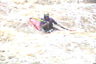
Sope Creek is one of the best whitewater runs in Metro Atlanta.
At high flows, around 1100 cfs or above 8 feet Sope Creek can turn into a solid class 5 run. At moderate flows its a class 3-4 run. At all flows the water quality is nasty. Sope is very polluted due to street runoff.
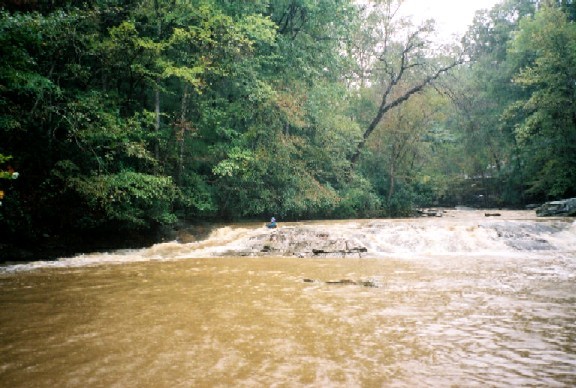
From the put-in on Lower Roswell Road there is about a mile of mostly flatwater. At higher flows there are two small surf waves and a good splat rock in this stretch. Eventually you will round a bend and the bottom will drop out.
The meat of Sope runs over a series of bedrock ledges. These ledges make for a series of fairly deep sticky holes. Sometimes they are punchable, sometimes they are not. The best way to get an idea of how Sope is running is to do a visual check from the bridge at Paper Mill Rd. If the hole immediatly past the bridge is the only thing that looks nasty, then the river is at a moderate level. If the hole has formed immediately above the bridge pilings, then you had better be on top of your game before putting on. Generally the hole above the bridge does not form until about 9 feet on the USGS gauge. I think that correlates to about 1500 cfs in a 65 foot wide ditch. 500 to 1000 cfs make much more sense in a streambed this size.
At high water the 4 ledges down to Paper Mill Road can form riverwide keeper hydralics. The top one recently held a boat for over a half an hour at high flows. The one below the bridge once held a 55 gallon drum for a couple of days.
Below the Paper Mill Rd bridge the rapids continue most of the way to the hooch. Its class 3 at normal flows, and class 3+ with no eddies at higher flows. Below the bridge at higher flows, dropping holes sideways so you can scout and surf at the same time is not unusual.
Sope Creek is also noted for a variety of large strainers that tend to relocate with every flood. Toward the end of the run are two pipes and one bridge that must be dealt with. At lower flows you can go under the pipes, sometimes you can go over them, and sometimes they are clogged with wood. Same with the Columns Drive bridge.
Sope only runs after a hard rain, and usually holds its water for less than a day. Be aware that the water level can go up over 1000 cfs in less than 30 minutes during a good rain. This recently caught a group by surprise. Read the story in the comments section at the bottom of the page.
_Updated June 2003_
Logistics:
Put-in below the bridge on Lower Roswell Road. About 100 yards east of the creek is a small side street and a semi-legal place to park.
The usual take out is the Metro Hooch put-in. Taking out at Columns Drive is a good way to get your car towed. They are serious about those no parking signs in front of the multi-million dollar homes.
For more adrenaline, about a quarter mile past the bridge on Paper Mill is a micro creek coming in on river left. If you feel like breaking your boat, carry up and run the falls by a putting green on the Atlanta Country Club. Its a back tweaker... but its been run by a couple of people.
Sope Creek runs about 2.5 miles between Lower Roswell Rd and Columns Drive.
The paddle out from Columns Drive to Powers Island is about another 2.5 miles.
Rottenwood creek, less than 5 miles away, can usually be run the same day that Sope runs.
National Park Service Map of Sope Creek.
Sope Creek Feet to CFS correlation:
Feet CFS 2.0??2.5593.01043.51574.02204.53005.03905.54856.05906.57257.08307.59708.011008.513009.015009.5172510.02000
Rapids in this Run (1)
Hazards & Portages (1)
Caution: The following locations may require scouting or portaging. Always check current conditions.
Difficulty
Class III-IV(V)
Length
4.7 mi
Gradient
39 ft/mi
max 120
Rapids
1
1 Hazard
Access Points
Difficulty Classes
I Easy
II Novice
III Intermediate
IV Advanced
V Expert/Extreme
VI Unrunnable
Current Conditions
5-Day Forecast
Whitewater data from
American Whitewater
American Whitewater