Luxemburg: Hwy.64 to Hwy.64 (4.6 miles)
Linked via: Nhdplus discovery 90% confidence Synced 6mo ago
Gauge Conditions
Runnable: 280.0 – 1,430.0 CFS
Almost certainly too low. Likely under 100 cfs.
Primary
Runnable: 100.0 – 500.0 CFS
Most likley too low for whitewater.
Data from American Whitewater & USGS
Run Map
Run Time Estimate
Select put-in and take-out to estimate time.
Unlock Advanced Trip Planning
See wind-adjusted speed maps, forecast planning, and detailed time estimates.
Sign in to generate an AI timing estimate for this run.
Whitewater timing varies with scouting, portages, and group pace. Use as a planning baseline.
Description
Quick Facts:
Location: approximately 17 miles due east from Green Bay.
Shuttle Length: 3.7 miles
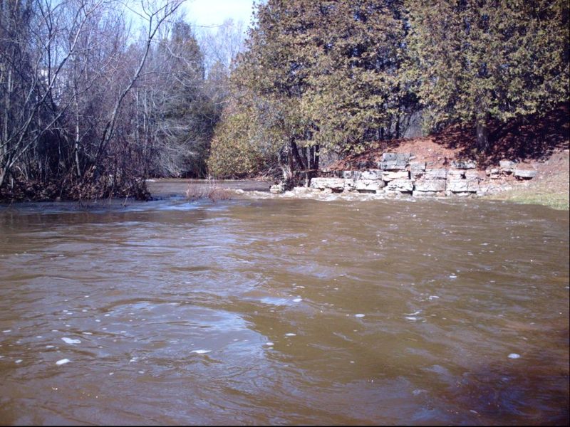
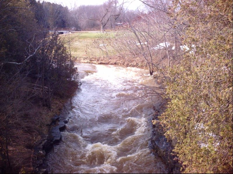
Character: Very scenic rocky outcroppings, cedar trees, a couple side-stream waterfalls (when wet); fairly continuous class I-II, with a fine ledge drop (II+/III-) at the edge of a golf course.
Put-in is approximately 755' elevation.
Take-out is approximately 657' elevation.
Thus total elevation change is approximately 98'.
General Overview
The overall gradient of this reach would suggest decent whitewater would be likely. Indeed, from behind the private properties on School Creek Trail, down to County Highway A (Main Street) to Valley Road (and slightly beyond) the creek is almost continuous class I-II boogie. A few areas will require a bit of navigational skills, but (with adequate flow) the stream is generally wide, farily clear of fixed obstacles (rocks), and free of deadfall or snags (at least as of spring, 2010), so it makes a very fine and scenic novice whitewater float.
The most difficult or 'tricky' spot on the run is right at CTH.A (Main Street). As the creek passes under the final bridge in North Brook Country Club, there are a few waves leading into a nearly 90-degree left-hand bend, down a short (1-2') ledge, followed immediately by a 90-degree right-hand bend leading into a vertical-walled 'dells' as the stream passes under the road. This area could prove difficult for beginner/novice boaters. (I would highly recommend people in canoes or recreational kayaks may need to back-paddle and try to be out of the strongest flow (head to the inside/right-side of the right-hand bend) to slow their craft, to keep from being pushed into the left wall of the dells under the highway.) Minor play (for more skilled boaters, in proper whitewater craft) may be possible at the golf-course bridge (just upstream), but virtually no play seems likely at the main ledge at most flows. There may be another spot or two which could allow minor play at some (high) flows, but generally boaters looking for whitewater 'playboating' will be disappointed.
The trip could be shortened via a couple other potential access points which would place you closer to (or right at) the head of the best gradient, and take-out before the confluence with the Kewaunee River. However, parking is generally less convenient at these alternate access points than at the locations listed here as put-in and take-out.
To ease possible concerns: often golf courses are notorious for having low (impassible at high water) bridges. Fortunately the bridges in this golf course are all high enough not to cause problems.
If/when this run is done, it is likely to be in concert with other rivers in the area.
Recommended 'Companion' Runs
Baird Creek 14.5 miles away
Bower Creek 22.6 miles away
Neshota/West Twin River 21.5 miles away
Devils River 24.1 miles away
Special Note: The real HUC for this reach should be 04030102. It has been 'faked' below to allow this reach to 'sort' (when listing is pulled up 'by drainage') into the 'Southwestern Lake Michigan' rivers, rather than the already bloated list of 'Northwestern Lake Michigan' rivers. If this somehow causes problems for anyone using this listing, please send a message to the Regional StreamTeam Leader (which can be done via the 'Add a Comment' button which should appear under the 'Comments' tab).
Rapids in this Run (4)
Playspots (1)
Hazards & Portages (1)
Caution: The following locations may require scouting or portaging. Always check current conditions.
Difficulty
Class I(III)
Length
4.5 mi
Gradient
21 ft/mi
max 43
Rapids
4
1 Hazard
Access Points
Shuttle Info
Alternate put-ins and take-outs are possible, for which the shuttle should be obvious from any map of the area.
You can use the text-entry box below to input your home or other starting address (it will accept not just zipcode as indicated, but full address: street city state) to get drive time, distance, and directions to the listed put-in.
Difficulty Classes
I Easy
II Novice
III Intermediate
IV Advanced
V Expert/Extreme
VI Unrunnable
Current Conditions
5-Day Forecast
Whitewater data from
American Whitewater
American Whitewater