Major Moore's Bridge to Gasquet Wild
Linked via: Proximity 99% confidence Synced 6mo ago
Gauge Conditions
Runnable: 1,200.0 – 7,000.0 CFS
Packraftable at 1,060 @ JED but recommend a little higher.
Data from American Whitewater & USGS
Run Map
Put-in
Take-out
Rapids/Hazards
Wild
Scenic
Recreational
Run Time Estimate
Select put-in and take-out to estimate time.
Unlock Advanced Trip Planning
See wind-adjusted speed maps, forecast planning, and detailed time estimates.
Sign in to generate an AI timing estimate for this run.
Whitewater timing varies with scouting, portages, and group pace. Use as a planning baseline.
Description
Flows
The water on this run is always crystal clear unless levels are high, and it's known as one of the most scenic runs on the West Coast. Good flows are available in the winter rainy season, October to April, when an average of 92 inches of rain falls. Summers are dry, so the rivers get too low for boating. There is a foot gauge painted onto a pipe near the take-out for the NF Smith, and it actually correlates pretty well (usually within 0.5' at medium levels) with the USGS Smith River near Crescent City gage. Here is what to look for on the pipe.
6' --- (very low) Has been done at least once by packrafters at this flow, they reported a fun day and a 7-hour trip.
7' --- (very low) Has been done at this flow by IK's, better suited to an overnight approach.
7.5' --- (low) Can be done in hard shell kayaks, but it's about the minimum for this craft.
8' --- A friendly low level for kayakers, and while doable in R2 style rafts some would consider it too low.
8.5' --- Low runnable for rafts, but a worthwhile flow for kayakers looking for more class III than IV.
9' --- A fun level, and a good mix of class III and IV.
10' --- Considered the ideal first time level in any craft. Expect a Class III/IV, pool and drop experience.
12' --- The connoisseurs flow, it becomes continuous and pushy, but still Class IV.
13.5' --- Has some mean spots, not a good flow for those without prior knowledge of the run.
14' --- Pretty filled in, big, fast and continuous. Still class IV (IV+) but unforgiving to a swimmer, with a few large features
16'-18' --- Becoming quite large, few or no eddies, strong boils and seams, very fast currents
19'-20' --- It has been run this high in kayaks and crafts built for big water. Here is *a video*.
\*note: the level of your run = when you float by at the end of the run, rather than when checking levels in the morning before running shuttle. If you'd like to study the correlation futher, check out the photo titled 'flow correlation data' in the gallery.
River
In addition to the clear water, several waterfalls pour into the river in beautiful cascades with pitcher plants and azaelas (a trip in spring will find them in bloom) lining the banks. There are a couple good lunch spots and if you really wanted to take it all in, an overnight self-support trip is also a possibility. Bottom line is this is a spectacular river trip on a Wild and Scenic River.
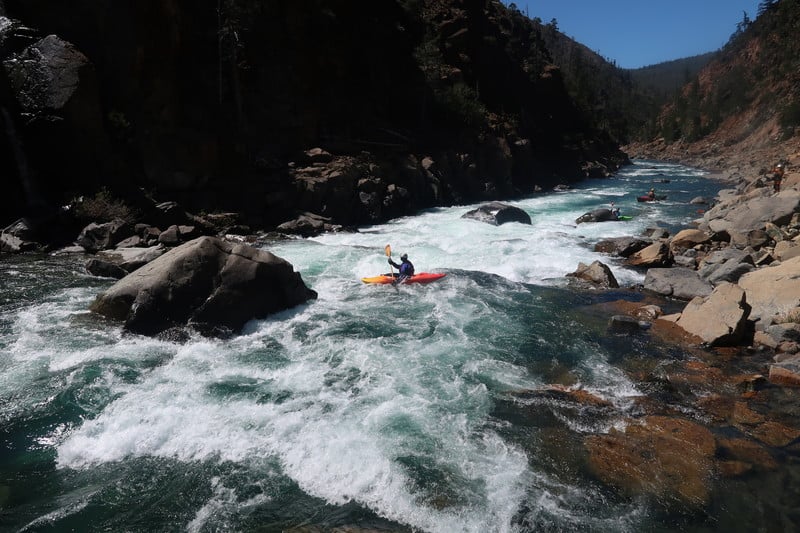
Most of the rapids can be boat scouted and at low to moderate flows this is a great Class IV pool-drop run. The one exception is Scout Rapid where it is helpful to hop out on the right and take a look at the sequence of moves you need to make. As flows increase, the pools disappear and the river becomes one continuous ride of big whitewater. At these levels, it is nice to have someone with you who knows where to stop for Scout Rapid, and where a couple of other notable features are located. Keep in mind that the run is very remote and you are a long way from any roads. A hike out would be epic, so come prepared for wilderness boating and don't put on when the water is too high for your skill level or when flows are ramping up quickly.
Since this is a long run a comfortable river cruiser is generally the boat of choice. Experienced kayakers can have a lot of fun in a half slice. While overcast rainy days can be the norm on this run, the river is absolutely spectacular on a sunny day. Bring a pair of sunglasses as you will be paddling south and the low angle sun on winter or early spring days can be blinding.
Packrafters in 2022 were able to boat this at 1,060 cfs on the USGS gage, but recommend at least 1,200 for those craft. At those flows this is an easy (but still remote!) Class III run.
Logistics
Take-out: There are two options for a take-out.
Gasquet Water Treatment Plant: This an informal access at the confluence of the North Fork with the Middle Fork. It is a standard take-out for kayakers running the North Fork. At Highway 199 mile post 14.3 in Gasquet, turn on to Middle Fork Gasquet Road. Follow this road 0.1 mile and turn right onto Gasquet Flat Road and follow it 0.1 mile to the bridge across the Middle Fork. If you park tight, you can get a few cars parked along the shoulder (please don't block driveways). To scout your take-out at the confluence, you will need to walk downstream river right of the bridge through the green gate, past the water treatment plant, and down to the confluence. It is a short hike with kayaks but not as practical for rafts.
Margie’s (aka Sims Camp or Shady Bend): This is a signed USFS river access site located at Highway 199 mile post 12.86 at the downstream end of Gasquet (just as you pass the highway sign marking the entrance to Gasquet where the river heads away from the road). The river is accessed by a gently sloped 370-foot-long double track trail. The site includes parking for 10 vehicles, vault toilet, and screened clothes-changing area. There is room for overflow parking off the highway shoulder. The access point is a small mud/sand beach and the river is a deep pool at this point. Adjacent to and in view of highway.
Put-in: where Low Divide Road crosses the river at Major Moore's bridge. The shuttle route climbs through the mountains west of the river, then drops back down to the river about 25 miles from the Highway 199 turn off. Driving time is around 1 to 1.5 hours one way. The road is reportedly not plowed in the winter but is somtimes kept open by locals with 4-wheel drive.
Shuttle Option: It takes a 1.5 hours or longer to get from the take-out to the put-in so most folks coordinate a shuttle driver in Gasquet. Contact driver David Gastineau via Facebook to organize a shuttle.
Other Information Sources:
CA Creeks
Jefferson State Creeking- blog
Oregon Kayaking NF Smith River.
Nate Dogg, blog report
NF Smith at 10' - Vimeo Video
For books, see: Cassady & Calhoun, Holbek & Stanley, Schwind, Penny, Soggy Sneakers
Smith - Wild & Scenic River
Six Rivers National Forest
Smith River Recreation Area
Rapids in this Run (2)
Difficulty
Class III-IV
Length
15.0 mi
Gradient
40 ft/mi
Rapids
2
Access Points
Difficulty Classes
I Easy
II Novice
III Intermediate
IV Advanced
V Expert/Extreme
VI Unrunnable
Current Conditions
5-Day Forecast
Whitewater data from
American Whitewater
American Whitewater