McCredie Hot Springs to Green Waters Park
Linked via: Proximity 90% confidence Synced 6mo ago
Gauge Conditions
Runnable: 3.0 – 3.5 FT
Data from American Whitewater & USGS
Run Map
Run Time Estimate
Select put-in and take-out to estimate time.
Unlock Advanced Trip Planning
See wind-adjusted speed maps, forecast planning, and detailed time estimates.
Sign in to generate an AI timing estimate for this run.
Whitewater timing varies with scouting, portages, and group pace. Use as a planning baseline.
Description
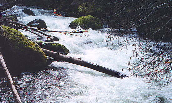
Not often run because it is thought to be "wood choked" this is a gem with consistent water from rain in the winter and snowmelt in the spring, good water quality, and lots of amusing rapids. Yes, you can expect to dodge a lot of big logs and portage a few, but it is not out of the ordinary for a smaller stream in the Pacific Northwest.
From the launch at McCredie's newly developed parking area the floating is technical class II down to Blue Pool and past it by .02 miles, and then the whitewater ramps up to III+ to IV depending on flow. Soggy Sneakers mentions two class IV rapids (Luggage Inspector and Unclaimed Baggage) but it is hard to tell which part of the whitewater is those named. There is a long (2+ mile) section of steep and technical class III+ whitewater with occasional lulls. After this section the gradient ramps down a little but it does not flatten, rather it becomes continuous class II+ to III with wood obstacles and occasional steep drops to keep you on your toes.
The run has a wilderness feel in spite of the fact that it runs parallel to Highway 58. The highway becomes obvious when the river and road are both steep enough that truckers are using their air brakes, and when you cross under the highway.
The description and photos offered at Oregon Kayaking is from 2000---the wood has moved.
Rapids in this Run (2)
Difficulty
Class III-IV
Length
9.8 mi
Rapids
2
Access Points
Shuttle Info
Put-in: McCredie Hotsprings Parking area on Highway 58. It's 9 road miles (slightly farther by river) from here to Oakridge Green Waters Park.
Possible put-in: Blue Pool Campground on Hwy 58 cuts off 0.7 miles of class II water but is gated when closed.
Possible takeout: Campsite at Milepost 42. There is no pullout from the highway so you will have to slow down in the road to make the turn. Watch for the mudhole.
Possible takeout: Kitson Springs Road aka Hills Creek Road bridge, just before the confluence with the MF Willamette.
Takeout: Green Waters Park in Oakridge, accessible from Highway 58. This takeout is less than a mile downstream from the confluence with the Middle Fork, river right just after a footbridge marking a popular riverside hangout.
Difficulty Classes
I Easy
II Novice
III Intermediate
IV Advanced
V Expert/Extreme
VI Unrunnable
Permit Required
No permit required. Run is mostly in US National Forest.
Current Conditions
5-Day Forecast
Whitewater data from
American Whitewater
American Whitewater