Newfound lake to Bristol
Linked via: Nhdplus gnis 95% confidence Synced 6mo ago
Gauge Conditions
Runnable: ? – ? CFS
Approximate reading: This gauge is 3.5 miles away on Newfound River. Use as a general reference only.
Data from American Whitewater & USGS
Run Map
Run Time Estimate
Select put-in and take-out to estimate time.
Unlock Advanced Trip Planning
See wind-adjusted speed maps, forecast planning, and detailed time estimates.
Sign in to generate an AI timing estimate for this run.
Whitewater timing varies with scouting, portages, and group pace. Use as a planning baseline.
Description
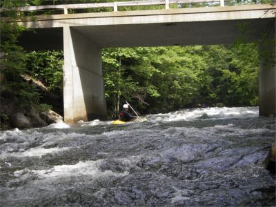
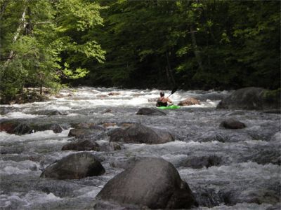
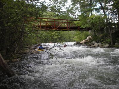
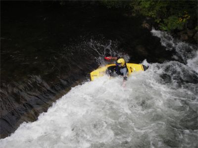
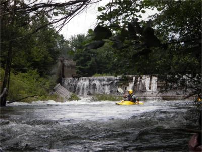
The Newfound is a seldom run river located near the more popular Pemi. This is a medium size river about 45' wide on average. It is broken up into three sections separated by two dams. The first mile is easier (class 2). You may portage the partially washed out dam on river right or scout this drop to run through on river right, perhaps 6 to 8 ft from the right wall. Below the first dam the river passes under the NH Rt 3A bridge then quickly increases in difficulty to class 3 at medium levels. There is a short breather where the rapids decrease in difficulty. Just above the bicycle path footbridge the main event starts. Old Mill rapid starts just upstream of the bridge then increases in difficulty up to class 3+ at medium levels. Be prepared to strike hard for shore if you find yourself separated from your boat since another dam awaits just downstream. The rapids calm to class 2 just before it takes a sharp turn back under the NH Rt 3A bridge then tumbles over another dam. Easiest take out is on river right just before the sharp right turn. This is the upper take out at the Newfound Lake Watershed parking area. If you should choose to continue downstream carry your boat across NH Rt 3A then behind the building adjacent to the dam. Mild class 2 rapids continue up to Bristol Hill Road take out on the right. Just above the take out bridge there is a river wide hole formed by a lowhead dam. This is not noticeable until you are right on top of it. There is good play here by good boaters with escape lines on either side of the hole.
Technical info
Put in elevation........587'
Take out elevation......463'
Total drop..............124'
Average drop/mile.......62'
Distance................2.0 miles
River width average.....45'
1st mile drop...........47' (includes ~6’ of portaged dam)
2nd mile drop...........77' (includes ~7’ of portaged dam)
River geology...........schists, small to medium boulders
River water quality.....good, clarity; good
Scenery.................mostly good to excellent, poor at dam portages.
Wildlife................merganzers, hawks
Rapids in this Run (3)
Playspots (1)
Hazards & Portages (1)
Caution: The following locations may require scouting or portaging. Always check current conditions.
Difficulty
Class II-III+
Length
2.0 mi
Gradient
62 ft/mi
max 77
Rapids
3
1 Portage
Access Points
Shuttle Info
To get to the put in drive north out of Bristol on route 3 to the blinking light just before the Lake and take a left. Take another immediate left on a dirt road just before the bridge. Drive down to the dead end just downstream of a dam run by the New Hampshire Department of Environmental Services.
Difficulty Classes
I Easy
II Novice
III Intermediate
IV Advanced
V Expert/Extreme
VI Unrunnable
Current Conditions
5-Day Forecast
Whitewater data from
American Whitewater
American Whitewater