Pike Lake Rd to Donken Tapiola Road (7.6 miles)
Linked via: Nhdplus gnis 95% confidence Synced 6mo ago
Gauge Conditions
Runnable: 6.2 – 8.0 FT
Almost certainly too low for reasonable whitewater experience.
Data from American Whitewater & USGS
Run Map
Run Time Estimate
Select put-in and take-out to estimate time.
Unlock Advanced Trip Planning
See wind-adjusted speed maps, forecast planning, and detailed time estimates.
Sign in to generate an AI timing estimate for this run.
Whitewater timing varies with scouting, portages, and group pace. Use as a planning baseline.
Description
A 4 mile access and 3.3 mile egress of moving water (broken only by random, very light rapids) nets you an exciting quarter-mile drop sequence.
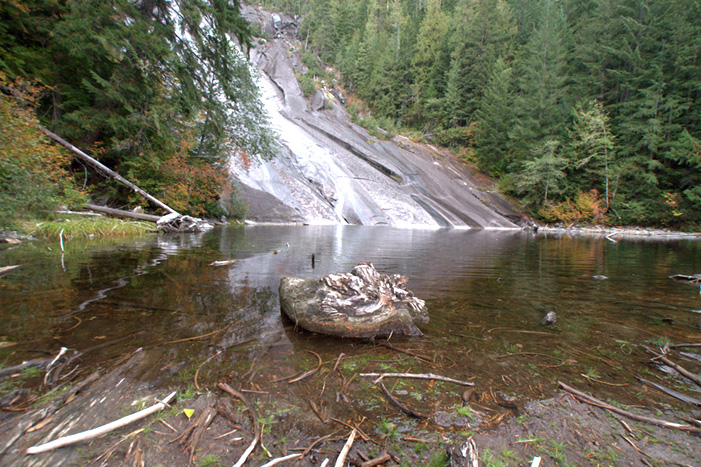
Just 150' after the confluence with Bruno Creek, the start of the Otter Falls sequence is encountered. This opens with a 5' sloping ledge that serves as fair warning that the main drop is just ahead. _Otter Falls_ is an extended low angle bedrock slide, with two steeper ledges of perhaps 5'-6' in close proximity near the start. This slide sequence extends for perhaps 200 yards before tapering off into light rockbed rapids.
Tauriainen Road (shown on maps) comes in (dead ends) very near this location. We are not sure whether part or all of that road may be private or how likely it is to be passable in early season or after heavy rains. If accessable, (and if the area is not all posted against trespass -- unknown to us at this time) it may alow a carry-up, huck, carry-out option as an alternative for seeing/running this falls sequence without doing a shuttle (and without having to run the (nothing-but-low-grade rapids) access and egress portions of this run. Google satellite view also shows a significant powerline clearing and has it marked as a road (though none is specifically visible, so it is likely a utility easement, and/or 4-wheeler/snomobile trail) coming into to river at 5.4 miles from the listed put-in (I.E., about a mile-and-a-quarter after the falls sequence). Absent one of those options working out, you are faced with an even more featureless paddle out of 3.35 miles. If the listed take-out at Donken Tapiola Road (off Hazel Swamp Road) is inaccessible early season, use Horoscope Road (listed on some maps as "Limestone Mountain Road"). This adds another 2 miles of low-gradient paddling (for a total of 9.6 miles from our listed put-in). Fortunately (if this stretch is paddled), while there are no real features apparent, it does appear to move along much better than the 3.35 miles after the falls.
A good companion piece to this reach may be the W.Br.Sturgeon, which is located about five miles to the south. The W.Br.Sturgeon is a smaller watershed, so if the Otter is low, it's near certainty the W.Br.Sturgeon will be also.
Rapids in this Run (15)
 Rapid
Rapid
Drainage area ~28.4 square miles.
 Rapid
II
Rapid
II
Possible wave/hole
Rapid
I
Very minor rips
Rapid
I
Possible minor rips
Rapid
I
Minor rips?
 Rapid
I
Rapid
I
Minor rips?
Rapid
I
Minor wave train
 Rapid
I
Rapid
I
Wave train
Rapid
II
Ledge/Wave/Hole?
Rapid
Confluence, Bruno Creek
Rapid
End of Otter Falls Sequence
 Rapid
Rapid
Minor rips
 Rapid
Rapid
Possible small ledge/wave/hole
Rapid
Powerline Crossing
Rapid
Alternate take-out
Waterfalls (1)
Difficulty
Class II(IV)
Length
6.3 mi
Gradient
33 ft/mi
max 67
Rapids
15
Access Points
Difficulty Classes
I Easy
II Novice
III Intermediate
IV Advanced
V Expert/Extreme
VI Unrunnable
Current Conditions
5-Day Forecast
Whitewater data from
American Whitewater
American Whitewater