Seboomook Dam to Roll Dam Campsite
Linked via: Nhdplus discovery 90% confidence Synced 6mo ago
Gauge Conditions
Runnable: ? – ? CFS
Approximate reading: This gauge is 12.5 miles away on Penobscot. Use as a general reference only.
Data from American Whitewater & USGS
Run Map
Description
### Technical info
```
Put in elevation........1017'
Take out elevation......968'
Total drop..............49'
Average drop/mile.......25'
Mile 1 drop.............10'
Mile 2 drop.............39'
Distance................2.0 miles
River width average.....180'
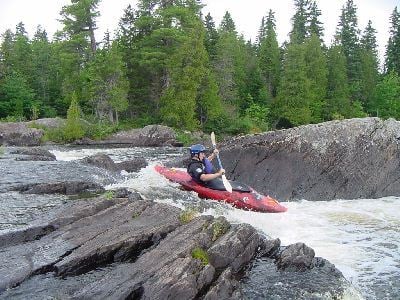
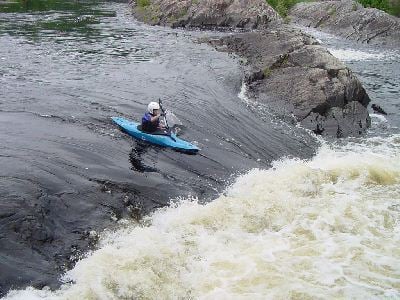
River geology...........ledge, many of them
River water quality.....excellent.
Scenery.................Beautiful north Maine woods forested scenery
Wildlife................Deer, Moose, bears, Merganzers, Hawks, eagles, comerants
```
### Description
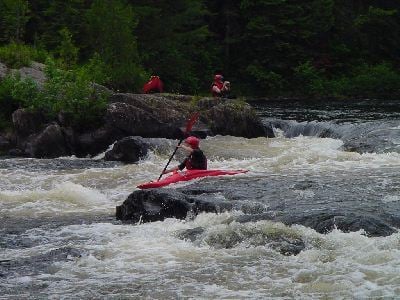
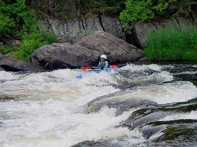
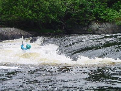
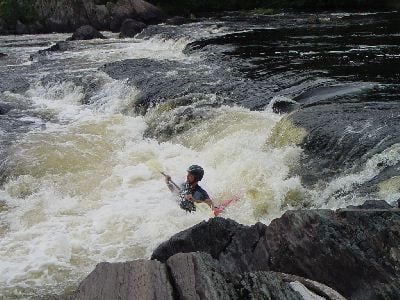
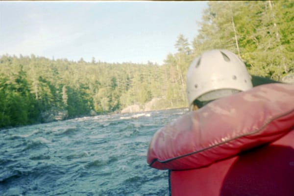
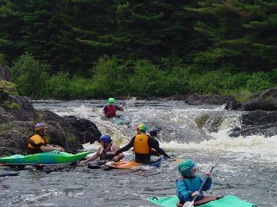
It's remote, accessed only by a driving a 37-mile dirt road, it will cost you $8 ($5 Maine residents) per person per day for the right to use this dirt road, and you have to paddle a half mile of flatwater before you get to the good stuff; but it's worth it. The Seboomook section of the West Branch of the Penobscot is a great place for almost any boating skill level at the low summertime release level. The drop and pool nature of this river is unlike most other New England rivers, which have long boulder strewn rapids. Novice paddlers will find they can carry any or all the drops without bushwhacking several hundred yards. If they choose to run, the drops are intense but very short with a large slow recovery pool below. Intermediate paddlers will find the Seboomook to be a great place to learn how to scout a rapid, boof drops and punch holes. Advanced paddlers will find challenge playing the holes at the base of the drops and boofing gnarly lines at E and I Ledges.
All in all the Seboomook is a great place to visit.
Says Bear, of the Northeast Paddlers' Message Board:
> Let's talk serious whitewater fun (those Honyaks in Maine have plenty!)...try your hand at paddling the West Branch of the Penobscot's Roll Dam section...no dam here, just a few miles of beautiful ledges/pool drops..but, more fun than a barrel of monkeys...if you mess up (open boaters w/out a roll like me), you simply pickup your canoe/self in the pool after each of the drops, climb back in on a ledge and drop into the next one...good clean water, easy access and of course the beauty of the Maine woods...class depends on flow, but probably a class 3 at medium flows... _wicked pissa fun_ in the hot summertime when running.
Brandon Cain adds:
> This is one of my favorite places to paddle. Scout Redrock and Meat Cleaver. The drops all have nice pools at the bottom, and this is a great place for paddlers of all skills.
>
> Posted on the MVP message board by Phil Urban on July 2, 2002
>
> Quite a few calls later... including John Frascella, one of our AW men/reps up here.... No telling about levels holding or not, but 3845 is probably a short term thing.
>
> Seboomook at 3845... 'Big, pushy, but not the Ottawa'. It really 'comes into its full glory' at 5000. John helped coordinate a flow study this spring and the highest they ran it was 2400. A couple people raved about the hole at the top at that level. 'A big fluffy rodeo hole'. At 2400, the rest of the run was quite similar to 1000, though some of the holes were filled in and less sticky. Everone I talked to expressed interest, or fondness, for it at levels like 3850. By today's rating standards, probably a class 4 run at this level.
>
> Canada Falls ( South Branch of the Penob.) . This gets a little harder to relate. When they did the flow study, the lake was _full_. They (John and some others that know that river as well as anyone) put on at what the 'new engineer' was saying was 900. The river was just up in the trees. More like what they new as twice that CFS 'traditionally'. John, a C1er, but a Cribworks regular, said that was all he wanted. But, because of the smallness of the impoundment, and no real flow gauge, the level drops as the release goes on. What was 1500ish today may be 1200ish tomorrow and 900ish the next day, even though the phone is telling us 1500. So, the phone info right now is not real reliable, except to tell us that they are releasing a goodly amount of water. If its in the trees when you get there, take a long hard look before you put on, but its not likely to be that high. There used to be a rock, in the water at the putin, that had 0,1,2,and 3 painted on it, I think the paint is still there. I've paddled it through that range, but not above. IMO, at those levels, it was still a class 4, 4+ run. If John is at the edge of his comfort zone, when its reaching the trees, then I've gotta figure that's a class 5 level. When I did it at '1000+' in the past, it was not in the trees at all.
>
> Seboomook is much more reliably measured when releasing, so what we have always known as 950 is still 950. Also, the West Branch is releasing 2800, but John (who lives there in the summer and knows that river \*very\* well) says that it is more like what we've come to know as 3000 to 3100. This is a level that punches up the difficulty considerably, especially compared to recent low flow seasons.
>
> John was excited (if you know John, he's an excitable guy :)) that I'm posting this to the MVP board. As with many of our hard won negotiated rec. releases, more boaters using the resource is a good thing. In this case the deal is not done, so y'all have a responsibility to come on up and have fun. :-) We boated there on Father's Day weekend, at 940 CFS, and our party of 7 was all alone, 'cept for the Otters, Mink, Loons, Moose etc, etc. Sorry this was so long, hopefully the info will be useful to some folks. How accurate all this info is, I don't know, how well I've relayed it is undoubtedly poor. :-)
>
> ## North Maine Woods Inc.
>
> The Seboomook section of the Penobscot lies in what is known as the North Maine Woods. North Maine woods is a consortium of private landowners (mostly paper companies), encompassing 3.5 million acres of working forest. It is rugged remote country many miles from the conveniences of modern day life. To get more information on access fees, gate locations and hours, camping information, etc. go to the North Maine Woods website.
>
> ## Directions
>
> It's not the easiest place to get to but the scenery is nice and the dirt roads are not too bad. You will want to start your trip into the small town of Rockwood Maine on the western shore of Moosehead lake. To get to Rockwood take exit 39 off of Interstate 95
>
> head north on ME 7
>
> In Dexter take a left and head north on ME 23
>
> In Guilford take a left and head north on ME 15/6
>
> This will take you to Greenville continue on ME 15/6 by taking a left in Greenville
>
> 15 miles will bring you into Rockwood
>
> Continue through the other side of town then stop at the Rockwood country store on the Moose river for supplies.
>
> If you are coming up from the Forks area take ME 201 north to Jackman
>
> Take a right onto ME 15/6 to Rockwood. It is approximately 50 miles from the Forks, there are other options to get here using logging roads but refer to the Maine atlas and Gazetteer for those options.
>
> Once in Rockwood at the country store get all your supplies including food and gas up your vehicle there are very limited services within the North Maine Woods region.
>
> From Rockwood
>
> Approximately 37 miles to the put in
>
> From the country store head west 1/2 mile, then take a right on the bridge over the Moose river.
>
> Bear right on the otherside of the bridge, pavement will turn to a good dirt road within a mile.
>
> 20 miles on this road to the '20 mile checkpoint' and gate run by a consortium of paper companies
>
> At the gate pay $8 per person per day ($5 Maine resident)
>
> Proceed towards Pittston Farm then take a right on Boyd road.
>
> Continue on this road approximately 12 miles until you see a sign for Seboomook campground
>
> Take a left here just before the campground then another immediate left at the next intersection. Seboomook campground does have limited but expensive supplies and gas if needed.
>
> Follow the road to the put in which is 1/2 mile further than the road to Seboomook Dam visible on your left as you are driving.
>
> You can either put in where the river comes close to the road at a washed out section that was repaired with boulders or a hundred yards before the washout at a small trail on your left.
Difficulty
Class III
Length
2.9 mi
Gradient
25 ft/mi
max 39
Rapids
9
Access Points
Shuttle Info
It's not the easiest place to get to but the scenery is nice and the dirt roads are not too bad. You will want to start your trip into the small town of Rockwood Maine on the western shore of Moosehead lake. To get to Rockwood take exit 39 off of Interstate 95
head north on ME 7
In Dexter take a left and head north on ME 23
In Guilford take a left and head north on ME 15/6
This will take you to Greenville continue on ME 15/6 by taking a left in Greenville
15 miles will bring you into Rockwood
Continue through the other side of town then stop at the Rockwood country store on the Moose river for supplies.
If you are coming up from the Forks area take ME 201 north to Jackman
Take a right onto ME 15/6 to Rockwood. It is approximately 50 miles from the Forks, there are other options to get here using logging roads but refer to the Maine atlas and Gazetteer for those options.
Once in Rockwood at the country store get all your supplies including food and gas up your vehicle there are very limited services within the North Maine Woods region.
**From Rockwood**
Approximately 37 miles to the put in
From the country store head west 1/2 mile, then take a right on the bridge over the Moose river.
Bear right on the otherside of the bridge, pavement will turn to a good dirt road within a mile.
20 miles on this road to the "20 mile checkpoint" and gate run by a consortium of paper companies
At the gate pay $8 per person per day ($5 Maine resident)
Proceed towards Pittston Farm then take a right on Boyd road.
Continue on this road approximately 12 miles until you see a sign for Seboomook campground
Take a left here just before the campground then another immediate left at the next intersection. Seboomook campground does have limited but expensive supplies and gas if needed.
Follow the road to the put in which is 1/2 mile further than the road to Seboomook Dam visible on your left as you are driving.
You can either put in where the river comes close to the road at a washed out section that was repaired with boulders or a hundred yards before the washout at a small trail on your left.
Difficulty Classes
I Easy
II Novice
III Intermediate
IV Advanced
V Expert/Extreme
VI Unrunnable
Current Conditions
5-Day Forecast
Whitewater data from
American Whitewater
American Whitewater