Smalley Falls to Long Slide Falls (1.4 miles)
Linked via: Nhdplus discovery 90% confidence Synced 6mo ago
Gauge Conditions
Runnable: 4.0 – 10.0 FT
Data from American Whitewater & USGS
Run Map
Run Time Estimate
Select put-in and take-out to estimate time.
Unlock Advanced Trip Planning
See wind-adjusted speed maps, forecast planning, and detailed time estimates.
Sign in to generate an AI timing estimate for this run.
Whitewater timing varies with scouting, portages, and group pace. Use as a planning baseline.
Description
The N.Br.Pemebonwon is a short run (or pair of 'quick hits') that may serve well as a 'chaser' to a day of paddling since it has such easy access. Both access points are located within Marinette County Parks off of Morgan Park Rd east of Hwy 141/8 near Pembine (follow Park Service signs). There is a nominal parking fee. Long Slide and Smalley Falls are both worth a look even if you don't intend to run the falls or paddle this reach.
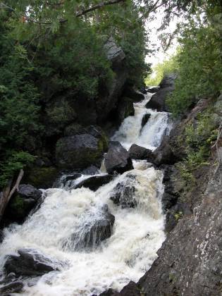
A trail from the parking area at Smalley Falls County Park leads you above or below the drop depending upon your skills, interest, and prevailing water level. Smalley consists of a fast approach, boulderbed and small ledge, to a complicated drop into a narrow chute. Total drop through the Smalley sequence is about 20'-25'. There are several small boulderbed rapids below this point and then a bit of moving flat-water before Long Slide Falls. Most boaters will be well advised to take-out above this drop (when it looks like the end of the world ahead) and carry to the parking area.
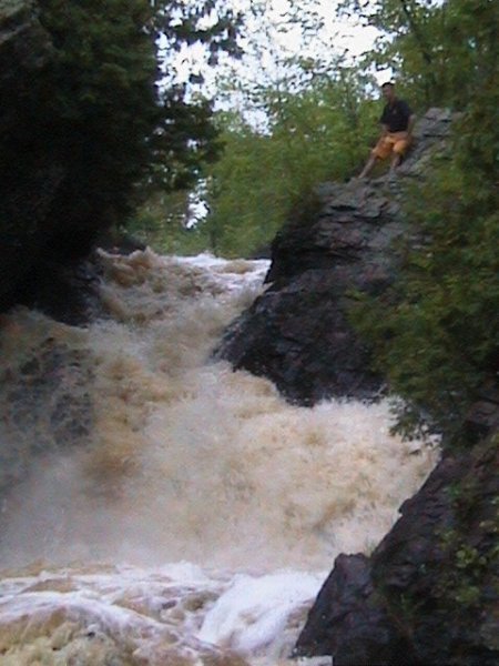
While the name 'Long Slide' may conjure up visions of fun, the actual drop is anything but. The drop is not a slide at all but a steep constricted bouldery cascade of 40'- 45' that often has chunks of wood lodged in it. There have been rumours of a run years back, and a more recent substantiated run (which, as I understand it, was 'not pretty'). Potential consequences of a mistake here are very high.
There are minor rapids, riffles and rips downstream, and a couple possible access points, but in general very little to recommend much additional paddling downstream.
This may pair well with its sister reach on the S.Br.Pemebonwon located several miles south.
Rapids in this Run (3)
Difficulty
Class IV-V
Length
1.4 mi
Gradient
49 ft/mi
max 61
Rapids
3
Access Points
Shuttle Info
Most likely done as a hike-in from the two different parking areas (in a county park) to either look at or run.
Difficulty Classes
I Easy
II Novice
III Intermediate
IV Advanced
V Expert/Extreme
VI Unrunnable
Current Conditions
5-Day Forecast
Whitewater data from
American Whitewater
American Whitewater