Source to Tellico River
Wildcat Creek (Tellico Tributary)
Linked via: Nhdplus discovery 90% confidence Synced 6mo ago
Gauge Conditions
Runnable: 5.0 – 7.0 FT
Data from American Whitewater & USGS
Run Map
Description
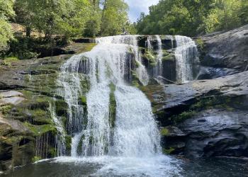
Really fun, tiny, and incredibly scenic run. Lots of trees throughout. The run has two distinct sections of class 3-4. The first section starts with the V8 minigorge and ends shortly after Reconnection, a good boof-to-slide affair of 12 feet. Some class 2 shoal rapids follow for a mile or two with maybe a sporadic class 3, then towards the end you get two to three more good class 3-4 boulder jumbles ending with The Icing--an 8 foot ledge with a great fading boof on the left shoulder--just 100 yards above the confluence with the Tellico. There is no class 5 in here as long as the water is not high. You will get the feeling of being one of the few to have done it.
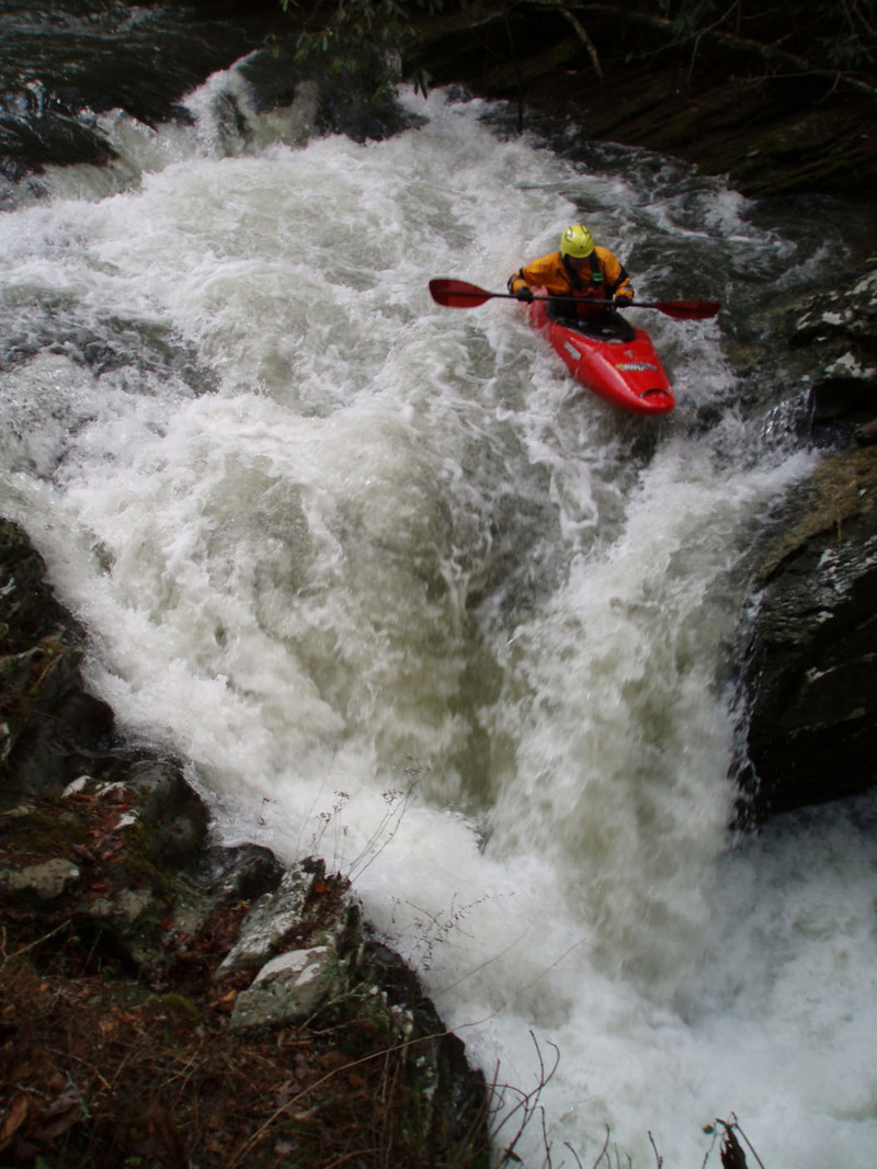
From Put In #1 (referenced in the directions) to the start of the V8 minigorge is approximately 0.6 miles. The gorge starts when the creek makes a hard, blind left turn through some faulted bedrock (will be hard not to notice). This is a must run. The gorge is 10 feet wide all the way through, narrowing to an exit just a little bit wider than your boat. If wood collects in here it will be difficult/impossible to avoid. From an eddy on river left about 30 yards above the start of the gorge, you can easily get to the overhanging lip and scout the entire length from this vantage point. Could portage from this side as well, just would take a little while.
For a good runnable level, look for Tellico to be 5 feet and rising, or for 2-3 inches of widespread low elevation rain in the past 12 hours. The Tellico should probably peak at least 6 ft for a medium level. Timing is important and putting on more than two hours after the Tellico has peaked may be too long. I would rate this run 3-4+. Good fun. Best run in the Tellico watershed. Don't put on too high, because of the wood though.
Waterfalls (2)
Hazards & Portages (1)
Caution: The following locations may require scouting or portaging. Always check current conditions.
Difficulty
Class III-IV+
Length
2.6 mi
Gradient
100 ft/mi
max 135
Rapids
0
1 Hazard
Access Points
Shuttle Info
Takeout: A few hundred yards downstream of the confluence with the Tellico at a pull out labelled "Wildcat Overlook".
To the Put-In: Drive down the Tellico to Old Furnace Road and turn left. This is right across from the Tellico Beach Drive In. Proceed up this road (past some initial "No Tresspassing" and "Private Property" signs--it is indeed a public road, so no worries) for two possible put in options.
Put In #2: At 2.2 miles, there is a gated road branching off to the right. There is a wide spot in the road, and on the left, a faint trail drops down a third of a mile to the creek. This puts you in below V8 and reconnection, making the run alot shorter and quicker, but you miss the cool minicanyon of V8. The run is a hair over two miles long puting in here.
Put In #1: At 2.9 miles, there is a sharp right turn away from the creek followed by a trail on the left, labeled 164. There is a wooden sign at the start of this trail that says "0.9 miles to Wildcat Creek, 2.2 miles to Wildcat Rd". The trail is small in places and goes uphill for two brief stretches. Stay right at an initial split where a trail seems to go to the left. Also stay right when the trail crosses a small creek and appears to split left again. Trees along the trail are marked with painted white squares approximately 3x3 inches each. Following this trail to the creek puts you in not far above V8 minigorge. This makes the run 3.25 miles long, and includes all of the good whitewater.
Another put in option is to drive upstream along the Tellico from the takeout, turning right onto Tellico River Road, and shortly later turning right onto a FSR crossing the river. Then proceed a number of miles to an unmarked trail on the right that leads 0.7 miles down to a put in on Sixmile Creek, a half mile above the Wildcat confluence. This adds 1.6 miles of scenic class 2, making the run almost 5 miles of wilderness.
Difficulty Classes
I Easy
II Novice
III Intermediate
IV Advanced
V Expert/Extreme
VI Unrunnable
Current Conditions
5-Day Forecast
Whitewater data from
American Whitewater
American Whitewater