Sturgeon Dam (0.3 - 2.0 miles) Wild
Linked via: Nhdplus discovery 90% confidence Synced 6mo ago
Gauge Conditions
Runnable: 250.0 – 1,000.0 CFS
Unconfirmed. Probably best flows for whitewater on this reach. (Likely 200-500 cfs.) We need your comments and reports to refine runnable ranges.
Runnable: 200.0 – 1,500.0 CFS
Likely low boatable flow. We need your comments and reports on how boatability and difficulty changes for this section at various flows.
Data from American Whitewater & USGS
Run Map
Put-in
Take-out
Rapids/Hazards
Wild
Scenic
Recreational
Description
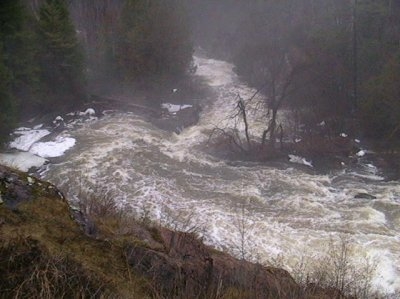
As a result of WE Energies Wilderness Shores Settlement Agreement, removal of the Sturgeon Dam (near Norway, MI) has resulted in a paddling destination which is convenient to a few other popular runs (Piers Gorge on the Menominee and Horeserace Rapids on the Paint).
The removal (started in the summer of 2003, completed autumn of 2005) yielded 0.3-0.6 mile of whitewater located in a scenic gorge. This should be big water class III and IV during the high flows of early season and more moderate class II and III in the summer months.
See additonal 'User Comments' attached below for the most recent information regarding this reach.
We will add that paddling groups may differ on their preferred access for this run. Our listing is a 'full run' (with a shuttle to the most convenient upstream put-in) which actually starts out with 0.3 mile on a very tiny side-creek. Once on the Sturgeon, there will be an additional mile of flat/flowing water before the significant action begins. Thus, many paddlers opt to just park at the take-out (former dam site) and carry up. However, doing so generally means missing the 'dells', as the carry-up trail veers far from the river and you would have to do some major bushwhacking to get to a place above the dells where you could again access the river.
For more information about this area, please see WE Energies Wilderness Shores.
Rapids in this Run (3)
Playspots (1)
Difficulty
Class III-IV
Length
1.6 mi
Gradient
15 ft/mi
max 35
Rapids
3
Access Points
Shuttle Info
Many boaters just do this as a carry-up, boogie-down, which allows scouting the crux final drops and the approach to them. However, the path encounters a dells and veers sharply away from the river, thus carry-ups will miss paddling that dells.
You may wish to use the text-entry box to input your home address or other starting location to get routing (drive time, distance, directions) to this boating destination.
Difficulty Classes
I Easy
II Novice
III Intermediate
IV Advanced
V Expert/Extreme
VI Unrunnable
Current Conditions
5-Day Forecast
Whitewater data from
American Whitewater
American Whitewater