Sweetwater Creek State Park to Chattahoochee River
Linked via: Nhdplus discovery 90% confidence Synced 6mo ago
Gauge Conditions
Runnable: 1.6 – 8.2 FT
After the Floods of 2009 a new gauge was installed. Min. 2.4 Max. 9.00 are the old flows. The new levels validated with several frequent local paddlers.
Data from American Whitewater & USGS
Run Map
Description
Gauge Description: Class III at low flows below 4 feet. Class IV above 5 feet on the gauge.
The falls are Class IV+. At 7 feet the falls are a Class V drop.
The river has been run a few times over 10 feet and possibly as high as 13. Floodstage Class 5 at these flows. LOCATION.--Lat 33°46'22", long 84°36'53", Douglas County, Hydrologic Unit 03130002, on right bank 100 ft upstream from bridge on Interstate Highway 20, 400 ft upstream from Blair Bridge, 3 mi southeast of Austell, and 5.5 mi upstream from mouth. More gauge info in text below. Sweetwater's drainage area is nearly 250 square miles, so it usually holds its water for a couple of days after a heavy rain.
Description: The Put-in for this run is in Sweetwater Creek State Park. There is a parking fee $5 for the day or $50 for the Annual pass. Once inside the park drive straight back to the interpretive center and park. Walk down the nature trail until you hit water.
A general rule of thumb is run down the left side channels from the first ledge until you get to the falls, but there are also other fun lines on the right but tend to collect wood. just scout as you go.
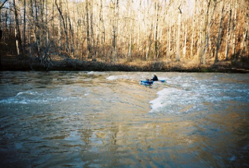
Below the put-in the river goes around a bend to the left. Just around the bend is a small riverwide ledge with some good surfing potential. Below this little wave hole is an island. Run to the left side of the island. Just past the island the gradient will start to pick up and the river will drop over more small bedrock ledges.
Take out on the left above the obvious horizon line.
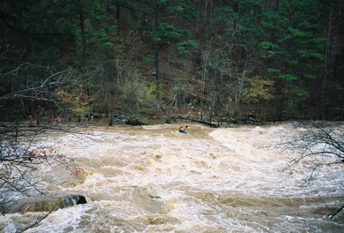
The first major drop encountered is a riverwide ten foot tall sloping ledge. This is generally scouted and run on river left.
There is also a route on river right. Its a good idea to scout this ledge as wood tends to gather at its base.
At higher flows a nasty low head dam type hole develops on this ledge in the center of the river.
In October 1995 a pair of novice boaters swam out of this hole at high flow and ended up spending the night on one of the islands. One of the local TV station's helicopters was used to drop food and blankets to the stranded boaters. Following this incident the park rangers were not particulary fond of kayakers. At the moment the Ranger/Boater relationship appears to have improved.
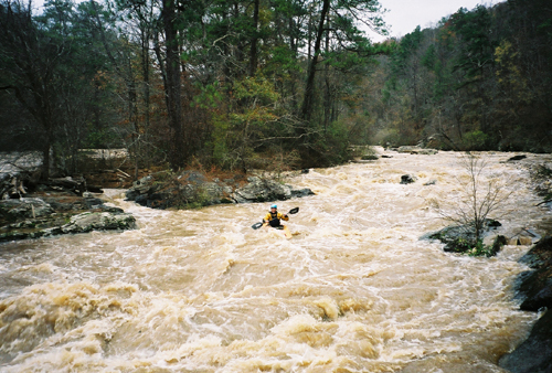
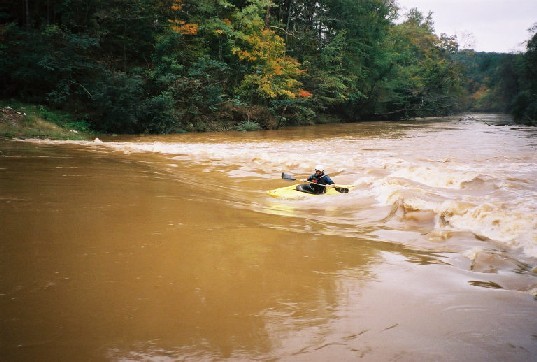
After the ledge the rapids thru Mill Shoals are pretty continuous for about a mile until the falls. From the ledge to the falls there are multiple channels and multiple routes. Our usual route is down the left channel. Above 6 feet this is one long class 4 rapid that would not be out of place in West Virginia. Be aware that every time the water comes up, all the wood in the stream relocates. Keep your eyes open.
According to the topo maps this stretch of river drops more than 80 feet in less than half a mile.
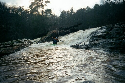
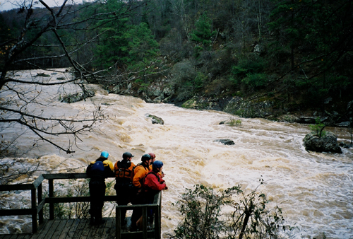
"The Falls" \- When you get to the downstream side of the islands, start working back to river right.
When you see the observation decks past the ruins, and an obvious horizon line, contemplate scouting.
Take out to scout on river right above the falls.
The falls are not really a vertical drop, but a big convoluted broken ledge. It's the biggest rapid on the river.
At low flows the usual route thru the falls is down the middle.
At medium to high flows drop over the first ledge into the eddy on river left. Then bust the move across the big curler from river left to right. From there, peel back out to midstream and thread your way between the center hole, the big hole on river left, and another smaller hole midstream.
At flows above 5 feet you can sneak the drop by boofing down the ledges on river right, or just use the nice trail beside the river to portage the whole thing.
Around 7 feet on the gauge the falls bumps up to Class 5.
Park & Play boaters have the option of boating down to the falls, then hiking back up to the put-in via the river right nature trail. There is detailed trail info below. The hole below the falls is pretty sweet in the 2.5 to 4 foot range. There is another hole on river left just below.
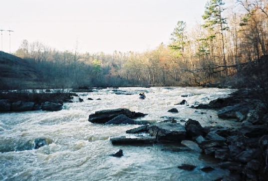
Below the falls are Four more rapids of note and some good play.
There is a good wave at high flows below the Powerline.
Take out is at the bridge on river right.
Gauge Info: The USGS gauge is on the north side of I-20 and does not readily correspond with the old bridge gauge.
You can no longer access the original gauge painted on the Blair Bridge piling just north of the park on the south side of I-20. There is a Douglas County water intake at that location with the usual homeland security fencing. The gauge is on the downstream river left side of the bridge piling. Two feet should be considered low, 4 feet good, and 6 feet would be high. The creek has been run upwards of 13 feet.
2500 cfs equals about 8 feet on the bridge gauge.
More Gauge info: 850cfs = 4 ft bridge gauge = 3.5 ft USGS gauge.
Shuttle:
Put-in: Exit off I-20 to Thornton Road southbound. Take a right at Blairs Bridge Road, the first light next to the Toyota dealership. After about 2 miles take a left onto Mount Vernon Road and follow the signs to Sweetwater Creek state park.
After crossing the lake make a left into the main entrance of the park. Follow the signs to the Nature trail parking lot.
Take out: Thornton Rd south to the last traffic light before you cross the Chattahoochee River.
Turn right on Riverside Pkwy. The takeout is the bridge over the river about 2.5 miles down the road.
Hike out: Hop out of your boat just below the falls on river right where the wooden stairs hit water level. Grab your boat and go up the stairs to the top of the hill. At the crest of the hill, take a left on the trail that keeps going up the hill, don't follow the riverside trail back down to the falls observation deck. When that trail ends, take a right on the Blue trail. Follow the very nicely groomed Blue trail back to the Mill Ruins. At the ruins veer right to the Red trail. Staying on the blue trail will take you on a scenic three mile hike. The red trail will stay by the river back to the put-in. From the put in take the obvious trail back to the parking lot. The hike out takes between 30 and 45 minutes.
You can also hike out by following the riverside trail all the way back to the put in. This is much more difficult than the blue trail option.
Georgia DNR Sweetwater Website.
NGeorgia.Com page on Sweetwater.
Friends of Sweetwater Creek Website has more good info including some good photos of the park.
_Last updated May 2006_
Rapids in this Run (5)
Waterfalls (2)
Hazards & Portages (3)
Caution: The following locations may require scouting or portaging. Always check current conditions.
Difficulty
Class III-IV(V)
Length
3.9 mi
Gradient
50 ft/mi
max 180
Rapids
5
3 Hazards
Access Points
Difficulty Classes
I Easy
II Novice
III Intermediate
IV Advanced
V Expert/Extreme
VI Unrunnable
Current Conditions
5-Day Forecast
Whitewater data from
American Whitewater
American Whitewater