to North Fork Reservoir
Linked via: Proximity 95% confidence Synced 6mo ago
Gauge Conditions
Runnable: 250.0 – 600.0 CFS
NF Clack generally has less water than the Fish Creek gauge indicates but is a much smaller creek. Can be run lower if low elevation rain event. Can be scouted
Data from American Whitewater & USGS
Run Map
Description
The NF Clack starts as a tiny river with some small rapids and gets progressively harder as boaters work their way down the river giving everyone a chance to get warmed up. The river is tiny throughout the run but most of the major rapids have a couple options. The first significant drop is an obvious horizon line on a sharp left turn. There is a second more difficult ledge just downstream so be sure to scout carefully. This rapid will give you a general idea of what to expect throughout the day. If you don't like this drop, seriously consider hiking out on the left on an old roadbed as it only gets harder downstream and exit access gets more difficult.
After about a mile and a half and a nice section of continuous rapids, be on the lookout for a gradual easing of the gradient after a sharp right turn. After this short break the river starts to enter some shallow bedrock slides on a gradual left bend. These slides end in a 10' waterfall which is shortly followed by a 45ft. unrunnable waterfall. Look for a faint trail on the left before the slides to portage both waterfalls or scout the first and then portage the second waterfall on the left up into the forest and down a steep gully which ends at the base of the waterfall.
The portage trail takes you high above the river before heading back down and downstream. The best way back down to the river is down a steep trail about 25 yards downstream of a steep creek coming in on the right side of the river. This puts you directly above a sweet 20-ft. waterfall, Stairway to Heaven. Needless to say, this section needs to be scouted carefully or go with someone who knows the river the first time.
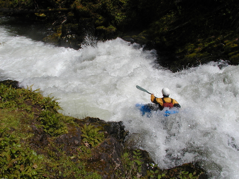
Stairway to Heaven is a wild ride through a big hole at the bottom. It is fairly easy to put-in at the base of the waterfall to set safety or to portage.
Below this waterfall the steep gradient continues but the rapids generally consist of boulder gardens rather than ledges and can have more wood and pin spots than the upper section. Very tight lines between boulders, logs and bushes make for some interesting boating. Most of the rapids are cleaner than they look but that's not saying too much. Just after you think you've had enough, keep your eyes peeled for a dangerous ledge drop. This is Storm Drain and is almost impossible to recognize your first time down the river. There are a couple small eddies above it which can be difficult to catch at almost all water levels. Do your best to scout this one as it pushes into an undercut on the left, drops onto a shallow shelf on the right and has a very powerful hole in the middle.
The next major rapid after Storm Drain is Double Blind Date, an exciting rapid where the river drops through some funky hydraulics and exits through a narrow slot and then careens over a steep, trashy boulder jumble. Double Blind Date can be scouted on the right.
After Double Bind Date, the rapids ease considerably although there has been considerable fish habitat work that has changed the channel and added wood in places.
See the description and photos at Oregon Kayaking.
Rapids in this Run (2)
Waterfalls (1)
Difficulty
Class IV(V)
Length
3.9 mi
Gradient
200 ft/mi
Rapids
2
Access Points
Difficulty Classes
I Easy
II Novice
III Intermediate
IV Advanced
V Expert/Extreme
VI Unrunnable
Current Conditions
5-Day Forecast
Whitewater data from
American Whitewater
American Whitewater