trailside
Linked via: Proximity 95% confidence Synced 6mo ago
Gauge Conditions
Runnable: 900.0 – 10,000.0 CFS
Data from American Whitewater & USGS
Run Map
Description
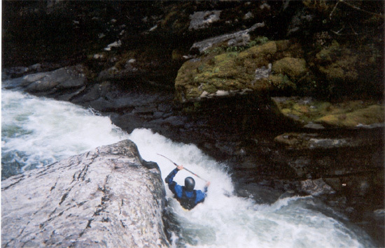
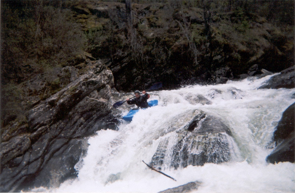
Kootenai Creek is the most accessible high quality creek run in the Missoula and Bitterroot valleys. The creek starts high in the Bitterroot Mountains and flows through a spectacular but low gradient glacial canyon before the bottom drops out about 1.25 miles upstream from the canyon mouth. The upper part of the run is studded with nice class III and IV drops seperated by short sections of calmer water. Then, the final quarter mile or so falls in a nearly continuous series of 3-10 foot bedrock drops. All these drops are fun and runnable, and an occassional eddy exists between them. The highlight for many is the 10 foot falls which requires a good boof and a river-right line to avoid the room of doom on the left. The bedrock nature of the creek and its easy access make it a staple for many area paddlers. Here is a video of the whole lower section with three laps off skinny hips and the falls.
The Kootenai Creek trailhead is located a short drive up N Kootenai Creek Road from Highway 93 and is well signed. You can't miss the big sawtooth ridges above the canyon. From the trailhead, hike up until you get tired or run out of gradient and put on. Be sure to carefully scout for wood on your hike up!
Most of the whitewater run is on private property, including the trail. Paddlers have two options for enjoying the creek in a manner that has been OK with the landowners. First, and recommended, is that paddlers run the creek and take out immediately below the last drop (before entering the little slot canyon) and walk the small trail up to the main trail, and then walk back to your car on the main trail. Second, if you really want to paddle through the slot canyon sometime go ahead and paddle out to the public road downstream. DO NOT take out after the slot canyon and hike up to your car, as this is trespassing and is not OK with the landowners. This is a really good system for paddlers based on mutual good-will. Please be appreciative and respectful, pick up trash if you see any, and follow these protocols.

Difficulty
Class IV-V
Length
1.7 mi
Gradient
250 ft/mi
Rapids
4
Access Points
Difficulty Classes
I Easy
II Novice
III Intermediate
IV Advanced
V Expert/Extreme
VI Unrunnable
Current Conditions
5-Day Forecast
Whitewater data from
American Whitewater
American Whitewater