Upstream of Miller Rd. Bridge
Linked via: Proximity 93% confidence Synced 6mo ago
Gauge Conditions
Runnable: ? – ? CFS
Approximate reading: This gauge is 3.4 miles away on Miller. Use as a general reference only.
Data from American Whitewater & USGS
Run Map
Run Time Estimate
Select put-in and take-out to estimate time.
Unlock Advanced Trip Planning
See wind-adjusted speed maps, forecast planning, and detailed time estimates.
Sign in to generate an AI timing estimate for this run.
Whitewater timing varies with scouting, portages, and group pace. Use as a planning baseline.
Description
SEASON: Fall rains and spring snowmelt
FUN FACT: Extreme steep creeking
TAKEOUT: Turn onto NE Old Cascade Highway from Hwy. 2 at mile
45.9 (you'll see the sign for Money Creek campground). Follow this road
0.9 miles to Miller River Road (FR 6410). Drive to the West Fork bridge
(mile 3.5 and elevation 1270'). Check road conditions with Mt. Baker - Snoqulamie National Forest;
follow link to the forest road conditions report under the recreation link.
PUT-IN: An old jeep trail, officially closed to vehicles in fall 2000,
parallels the river along river left. The gradient tapers off and you can find
a good put-in after about two miles of hiking and scouting.
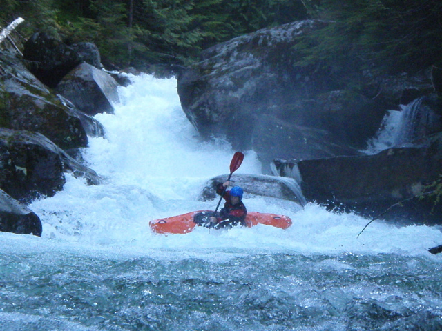
DESCRIPTION:
Some extremely steep boulder gardens and a couple of marginally
runnable waterfalls. Tao Berman ran the upper one known as Borderline
and Bryan Urakawa ran the lower one which is Immigration Falls. You can
scout the run as you hike to the put-in. Log hazards have been significant
in recent years.
Submit a comment if you have a good photo, wish to contribute a run
description, or would like to take over as Streamkeeper.
lat/long approximate by Tiger server
for additional information see:
- Mike Lawson's description in: Bennett, J. and T.
Bennett. 1997. A guide to the whitewater rivers of Washington, second
edition. Swiftwater Publishing. Portland, OR.
- Skykomish Ranger District - USFS Mt. Baker - Snoqualmie \
National Forest website
Waterfalls (1)
Hazards & Portages (1)
Caution: The following locations may require scouting or portaging. Always check current conditions.
Difficulty
Class V+
Length
1.3 mi
Gradient
312 ft/mi
max 640
Rapids
0
1 Hazard
Access Points
Difficulty Classes
I Easy
II Novice
III Intermediate
IV Advanced
V Expert/Extreme
VI Unrunnable
Current Conditions
5-Day Forecast
Whitewater data from
American Whitewater
American Whitewater