Windy Hill Rd to Chattahoochee River
Linked via: Proximity 81% confidence Synced 6mo ago
Gauge Conditions
Runnable: 250.0 – 1,000.0 CFS
Data from American Whitewater & USGS
Run Map
Description
Gauge Description:
Visual from one of many bridge overpasses. (Delk, Terrill Mill, Windy Hill, Windy Ridge, Interstate North, I-285, and Akers Mill)
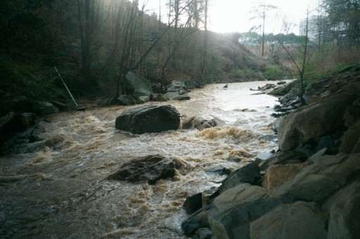
Rottenwood only runs after heavy rains, and runs off quickly. It can spike up and down over 1000 cfs in less than an hour.
November 2007: USGS now has an online gauge. It does not corelate with the Maxwell gauge. REPORT YOUR RUNS.
_Update 9-01-2003_\- New Gauge:The gauge is on the Interstate North Parkway SE bridge. It is a painted gauge on the downstream side of the center set of pylons. It is best viewed from river right next to the large 'Interstate North Parkway 180' sign.
0 inchs - passable. This is around 200 cfs on the USGS gauge.
2 feet - padded.
3 feet - beefy
River Description:
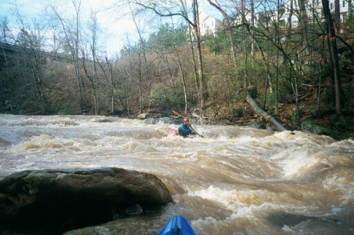
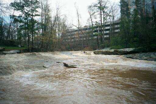
Rottenwood has some fun whitewater rapids ; The Creek flashes quickly after the rain event and the water is often the color and consistency of a chocolate milk shake. The water quality is not always the best so use good judgement on protective gear.
The creek is easy to scout from the small hiking park. There is a very nice hiking trail along most of the creek now.
Akers Mill rapid can get into the class 4 range with higher flows.
Above Akers Mill is a nice ledge drop that resembles a low head dam at higher flows. Beware of the undercut left bank. This drop used to be called Confederate Life, named after the multi-story office building beside it. The building has since changed ownership, currently Ascent Insurance. See the Rapids tab for more detailed info.
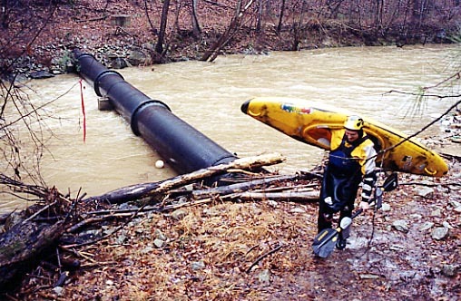
A word of caution would be to watch out for the large (3 to 4 foot diameter) pipe toward the end of the run. At low flows water runs under the pipe, at flood water runs over the pipe. Last checked there was a lot of wood jammed on the upstream side of the pipe, and not much of an eddy above it. Most people carry around the pipe on river left.
Rottenwood has been run at some rediculously high levels. Use your best judgement before putting on. If Rottenwood is rising you might find yourself running the rapids dodging mobile strainers, and other assorted trash.
Rottenwood and Sope can usually be run back to back with some creative shuttle work.
_Bradley. Posted April 2001, Updated March 2002, revised August 2008._
Logistics: The Put-in is just below the Health Club off Windy Hill Rd, on 1 North Parkway. There is a creekside parking area where Poplar Creek drops into Rottenwood Creek.
Use the park on the Hooch at Hwy 41 for a take out. Be current on your Hepatitis shots.
If your gear is _REALLY_ smelling like an oil spill, there is a car wash about a mile away on Spring Road in Smyrna.
National Park Service map of the takeout: West Palisades.
Hazards & Portages (3)
Caution: The following locations may require scouting or portaging. Always check current conditions.
Difficulty
Class III-IV
Length
2.9 mi
Gradient
50 ft/mi
max 100
Rapids
0
3 Hazards
Access Points
Difficulty Classes
I Easy
II Novice
III Intermediate
IV Advanced
V Expert/Extreme
VI Unrunnable
Current Conditions
5-Day Forecast
Whitewater data from
American Whitewater
American Whitewater