How's Your
River
×
Explore
Explore Map
Water Bodies
Gauges
Access Sites
Tidal Stations
Whitewater
Pricing
Login
Sign Up
Hazard Warning:
Hazard information may be user-submitted and unverified. Conditions change frequently. Always scout rapids and obstacles yourself.
Whitewater
South Carolina
Oconee Creek - Hwy 11 to Little River
Dam Drop
Hazard
SC
Class IV
Dam Drop
Oconee Creek - Hwy 11 to Little River (SC)
Monitor this Rapid
Water Body
This Run
Map
Other Rapids
Gauge
Weather
Directions
Gauge Conditions
Primary
Runnable: 200.0 – 100,000.0 CFS
Data from
American Whitewater
&
USGS
Photo
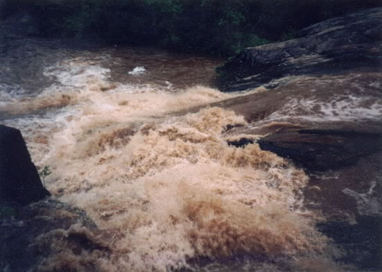
Photo courtesy of
American Whitewater
Description
This rapid is not as easy or straight forward as it might appear. The main dangers are trees and man made debris.
Location
Radar
Counties
Cell
Verizon
AT&T
T-Mobile
Dark
Satellite
Terrain
Other Rapids on This Run (2)
Rapid
N/A
Put In
0.0 mi
Rapid
N/A
Take Out
1.0 mi
Type
Hazard
Difficulty
Class IV
Mile Marker
0.1 mi
Directions
Navigate
View Full Run
Hwy 11 to Little River
Oconee Creek
II-III
1.9 mi
Hazard
— Exercise extreme caution. Portage recommended — scout before running.
Current Conditions
5-Day Forecast
Whitewater data from
American Whitewater
Dam Drop