Gauge Conditions
Runnable: ? – ? CFS
Approximate - nearest available gauge. Use as general reference only.
Data from American Whitewater & USGS
Photo
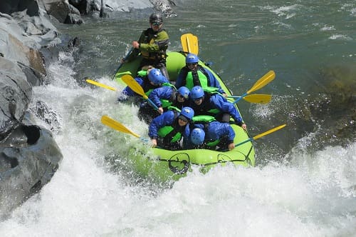
Photo courtesy of American Whitewater
Description
Take Out rapid marks the end of this Crystal River section, featuring a complex boulder garden that requires precise maneuvering between large, irregularly placed rocks. Paddlers must carefully choose their line, watching for potential pin and entrapment hazards, with the most navigable route typically hugging the river right side during moderate to high water levels.
Location
Other Rapids on This Run (1)
View Full Run
01. To Scree Slope
Crystal, North Fork
V+
0.6 mi
Current Conditions
5-Day Forecast
Whitewater data from
American Whitewater
American Whitewater