Take-out
MO
Take Out
Stouts Creek - 3. (Lower Stouts) Lake Killarney to St. Francis River (4.7 miles) (MO)
Gauge Conditions
Runnable: 5.0 – 10.0 FT
Anyone with info on boatable correlations is invited to add a 'comment'.
Data from American Whitewater & USGS
Photo
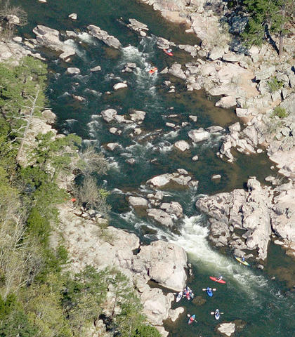
Photo courtesy of American Whitewater
Description
Take Out rapid marks the final descent before the St. Francis River, featuring a straightforward but potentially technical exit with scattered boulder gardens and potential route-finding challenges. Paddlers should scout for submerged rocks and choose a clean line, with caution advised during lower water levels when route selection becomes more critical.
Location
Other Rapids on This Run (1)
View Full Run
3. (Lower Stouts) Lake Killarney to St. Francis River (4.7 miles)
Stouts Creek
II
5.1 mi
Current Conditions
5-Day Forecast
Whitewater data from
American Whitewater
American Whitewater