USGS Sampling Site
Black, Little - Stub off US2 to Black River above Gabbro (2.35 miles) (MI)
Gauge Conditions
Approximate - nearest available gauge. Use as general reference only.
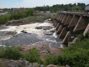
Photo
Description
USGS lists a sampling site (just upstream of our listed put-in) with drainage of 28 square miles.
That is very similar drainage area to E.Br.Huron (26.4 sq.mi. just DS of E.Br.Falls), Upper Yellow Dog (31.8 sq.mi. at put-in), or Lower Silver (34.5 sq.mi. at Arvon Rd, take-out for upper, put-in for lower). This is just for size comparison, and not to suggest the runs are comparable, nor that flows would directly correlate. In fact, with the Sunday Lake drain into Planter Creek, this run is likely to have substantially less flow (maybe half?) compared to what those others might get.
NOTE: Our 'calculated gauge' uses the gauge on the (main) Black, multiplying by a fraction based on drainage areas. We do not know the likely split between Planter Creek vs Little Black. If it tends to be equal amounts, that would mean our calculated gauge likely reads twice what it should.
Location
Other Rapids on This Run (4)

Current Conditions
5-Day Forecast
American Whitewater