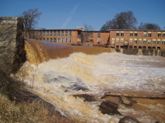
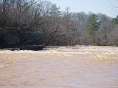
How's Your
River
×
Explore
Explore Map
Water Bodies
Gauges
Access Sites
Tidal Stations
Whitewater
Pricing
Login
Sign Up
Hazard Warning:
Hazard information may be user-submitted and unverified. Conditions change frequently. Always scout rapids and obstacles yourself.
Whitewater
Georgia
Yellow - 4. Brown Bridge Road to Hwy 212 (above Lake Jackson)
Cedar Shoals
Portage
GA
Class III+
Cedar Shoals
Yellow - 4. Brown Bridge Road to Hwy 212 (above Lake Jackson) (GA)
Monitor this Rapid
Water Body
This Run
Map
Other Rapids
Gauge
Weather
Directions
Gauge Conditions
Yellow River at Gees Mill Road, near Milstead, GA
Upstream
Primary
Runnable: 400.0 – 3,000.0 CFS
Data from
American Whitewater
&
USGS
Photo
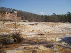
Photo courtesy of
American Whitewater
Description
Put in after portagaging the 12 dam on river right. Run the right side at lower flows, at higher flows a left hand channel opens up. At really high flows this rapid can aproach Class V
Location
Radar
Counties
Cell
Verizon
AT&T
T-Mobile
Dark
Satellite
Terrain
Other Rapids on This Run (3)
Rapid
Dam
0.0 mi
Rapid
III
Middle Shoals
1.0 mi
Rapid
III
Takeout Rapid
2.0 mi
Type
Portage
Difficulty
Class III+
Mile Marker
0.0 mi
Directions
Navigate
View Full Run
4. Brown Bridge Road to Hwy 212 (above Lake Jackson)
Yellow
III-IV(V+)
14.6 mi
Portage recommended
— Scout before running and consider carrying around this feature.
Current Conditions
5-Day Forecast
Whitewater data from
American Whitewater
Cedar Shoals