1. Highway 49 Bridge (Waterville Valley) to Campton
Linked via: Nhdplus discovery 90% confidence Synced 6mo ago
Gauge Conditions
Data from American Whitewater & USGS
Run Map
Description
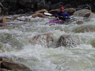
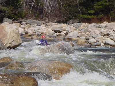
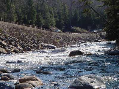
The Mad has a relatively short season due to its small and steep watershed. When it is running this is one of the longest stretches of continuous class III-IV whitewater in the state. Be cautious of rain or warm days in the spring when you are at the put-in. The river can rise up from low to too high by the time you reach the gage 6 miles down river. On one occasion in May of 1994, a group put on in a light rain. The rain along with snowmelt from higher elevations of the watershed raised the river to a ragging torrent about 4 miles into the trip. Many boats, and paddles were flushed downstream as their occupants were rescued and found their way out. Most of this group took off at this point.
### Technical info
```
Put in elevation........1417
Take out elevation......751
Total drop..............666
Average drop/mile.......85
Distance................7.8 miles
1st mile drop...........46
2nd mile drop...........118
3rd mile drop...........46
4th mile drop...........95
5th mile drop...........118
6th mile drop...........122
7th mile drop...........95
7.8 mile drop...........26
River width average.....25
River geology...........small to medium granite boulders
River water quality.....Good, clear except for quick runoff periods. Small sewage treatment plant at put in.
Scenery.................Good to excellent mountain and forest scenery. Route 49 occasionally visible along the river.
Wildlife................Occasional deer, moose, hawks
```
### Food, lodging, gas, etc.
Food:
On route 49, Mad River Tavern: Good food moderate price. Pizza and subs available at the Lower Village store on route 175. Take a right after the lights.
Lodging:
Expensive hotels and condos available in Waterville Valley. Scandinavian Inn located at exit 28. Several Bed and Breakfast establishments. Less expensive motel located at exit 27.
Campgrounds:
Campton campground, located on route 49 about 2 miles from exit 28, is run by the National Forest Service is open year round has some open group sites and nice wooded tent and small camper sites with picnic tables, modern outhouses, pump water, no electricity.
Osceola campground also run by the National Forest is located on the east end of Tripoli road (exit 31) near Waterville valley. Open May to November, open sites with views of the surronding valley. Picnic tables, modern outhouses, pump water, no electricity.
Branch Brook campground located on route 49 west of exit 28 is a familly campground with water and electric hookups for campers.
Gas:
There are several gas stations right at the exit but it is expensive. The further south on 93 you get gas the less expensive it is. Exit 20 in Tilton (30 miles south) has the cheapest gas in the region.
Etc.
Waterville Valley has is a recreational town with many hiking trails to six 4000 foot peaks surrounding the valley. You can also find skiing, mt biking, golf, etc. within the valley.
Outback Kayak located 12 miles north in Lincoln is the only full service kayak shop in the region. Some limited supplies might be available at Ski Fanatics at Campton Plaza immediately off exit 28.
## Directions
### Put in
Interstate 93 to exit 28. State route 49 east for approximately 10 miles.
Take a left at the Waterville Valley ski area access road.
1/4 mile take a right by the gas station/country store (Mountain Petroleum).
Drive up to the recycling area just past the store.
The put-in is down a steep bank on the left.
There are other possible put-ins upstream from this point, chech a map for other alternatives.
### Take out
Head back in the direction you came on route 49.
6 miles at Upper Mad river road is one possible take out.
8 miles at Goose Hollow (where rt 49 crosses river.
8.5 miles at 'The Eddy' White Mountain national forest recreation area.
Note: At the first and Last locations stated above, it will be necessary to have a White Mountain National Forest parking sticker. These can be purchased at the information center just off the exit for rt 49.
Rapids in this Run (3)
Difficulty
Class III-IV
Length
7.6 mi
Gradient
85 ft/mi
max 122
Rapids
3
Access Points
Difficulty Classes
I Easy
II Novice
III Intermediate
IV Advanced
V Expert/Extreme
VI Unrunnable
Current Conditions
5-Day Forecast
Whitewater data from
American Whitewater
American Whitewater