2. Elkhorn Campground to Six Mile Bridge
Linked via: Proximity 98% confidence Synced 6mo ago
Gauge Conditions
Runnable: 225.0 – 2,000.0 CFS
Runnable: 2.0 – 5.5 FT
Data from American Whitewater & USGS
Run Map
Run Time Estimate
Select put-in and take-out to estimate time.
Unlock Advanced Trip Planning
See wind-adjusted speed maps, forecast planning, and detailed time estimates.
Sign in to generate an AI timing estimate for this run.
Whitewater timing varies with scouting, portages, and group pace. Use as a planning baseline.
Description
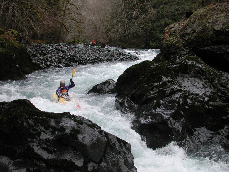
This section of the Dosewallips is a high quality run through a forested setting with a couple of really fun class IV rapids. It flows on heavier rains in the fall and then the winder and snow melt in the spring with a season that is typically from November to June. Low elevation snow can limit access to the put-in. Elevation at the put-in is around 650'.
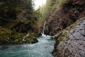
The meat of this run starts near the beginning with The Maze (check out the back cover photo on Gary Korb's Paddle's Guide to the Olympic Peninsula). This challenging class IV+ rapid consists of a boulder garden with a long (~500 yds.) complex series of chutes that have to be negotiated. It's easy to scout from the road on the way to the put-in where you can also decide to put in below the Maze if you wish. It can be difficult to find this rapid at the right level. At low water levels there just aren't many good routes, while there are plenty of places to get pinned. At high water things get a little fast and hairy (it doesn't take much to push this to class V).
After the Maze, the pace of the river mellows as you pass through a few more boulder gardens and some fun little rapids. The middle section can be a little long at the lower limit of flows if you came for the class IV action, but if you came for just a small shot of class IV adrenaline then the middle section is quite enjoyable and has fantastic scenery on a clear day. Below the washout, there are several miles of good continuous class III rapids making it a good introduction to creeking at the lower range of flows. Wood is always an issue on this run so stay alert.
Towards the end of the run the pace picks up again as you approach the Pinch. The rapid above it can be seen as you're driving to the put-in (just upstream of the turn-off for FR 2620). There is a mid-stream island with a good route along either side. The left channel slams into a bedrock wall and then makes a hard turn to the right. The right channel is down a steep couble bar that can be tricky to enter at lower flows. At river level the drop is tricky to boat scout but it can be done if you can catch the small eddies along the left. Alternatively, hop out at the top of the island for a look. You'll then have a short recovery stretch through a narrow bedrock chute before you reach The Pinch. Depending on flows and your skills you can often boat scout it, but it's best to either scout when setting shuttle or scout from well above as it can be tricky to get out at the lip. The river slices through a bedrock chute which takes you from left to right before making a hard turn to the left through The Pinch where most of the current passes through a narrow slot that's not visible from the top of the rapid--just make sure you're not floating sideways. Depending on flows, the hole at the bottom of the Pinch has given some boaters trouble.
Use caution in this final section as there are places where wood becomes lodged between the bedrock walls. The land around Six Mile Bridge is privately owned so stay below the high water mark to scout and be polite to the property owners.
Shortly after crossing under the bridge you reach the takeout on river right. Take out at or below the midstream boulder in the riffle below the bridge and hike up the spur road to avoid private property. Watch out for dogs, especially if you plan to bike shuttle...
ACCESS: From Highway 101 mile 306.0 turn up Dosewallips River Road (FR 2610). To reach the take-out follow this road 5.9 miles to FR 2620 (unmarked) which is the turn-off for Six-Mile Bridge. Follow this road 0.1 mile down to the bridge. Watch for dogs. From the signs along the road you might think you are on a private driveway but it is in fact a public Forest Service road. Stop on the bridge to check out The Pinch, but avoid the private property that includes the land on both sides of the bridge and down to the river. To find public access continue across the bridge and immediately turn left onto a short 2610-010 spur road that dead ends within 100 yards. Float just past the river center boulder in the riffle beyond the bridge and hike back up this spur road to avoid private property,
To reach the put-in, return back to FR 2610 and continue up river. At mile Dosewallips River Road mile 6.3 you will pass an alternate access point at a pull-out on river left that is Forest Service land. It is a steep carry to the water here. The pavement ends at mile 6.8 and the road currently ends at mile 8.6 at the Dosewallips River Trailhead where a plugged culvert resulted in a road washout. You can access the river here with a short hike to the shoreline. Those who want to run the Maze will need to continue upstream by hiking on the old bed which is now a trail on river left. The major washout where 300 feet of road was washed away in January 2002 is at Dosewallips River Road mile 9.8. A low route along the river bank and a high route through the forest provide two alternatives to hike around the washout. The Elkhorn Campground, the historic put-in for this run, is at Dosewallips Road mile 11.0. Picnic tables and fire rings have been removed and the outhouse has been boarded shut but the campground still remains as a beautiful spot along the river popular with hikers and bicyclists who continue to use it.
Check the Olympic National Forest web site for current road conditions. During the winter, snow sometimes limits passage beyond mile 6 unless you have a high-clearance truck. Shortly beyond this point, however you enter the National Forest and the river closely parrellels the river providing you with several alternate access options.
for additional information see:
- Korb, G. 1997. A paddlers guide to the Olympic Peninsula. third edition.
- Bennett, J. and T. Bennett. 1997. A guide to the whitewater rivers of Washington, second edition. Swiftwater Publishing. Portland, OR.
- Hood Canal Ranger District, North - USFS Olympic National Forest web site
Difficulty
Class III-IV+
Length
5.4 mi
Rapids
5
Access Points
Difficulty Classes
I Easy
II Novice
III Intermediate
IV Advanced
V Expert/Extreme
VI Unrunnable
Current Conditions
5-Day Forecast
Whitewater data from
American Whitewater
American Whitewater