2. Marriottsville Rd to Patapsco, N. Branch confluence "McKeldin Falls"
Linked via: Proximity 94% confidence Synced 3mo ago
Gauge Conditions
Data from American Whitewater & USGS
Run Map
Description
Note: read below and/or click the Map tab to see the multiple access points for this section.
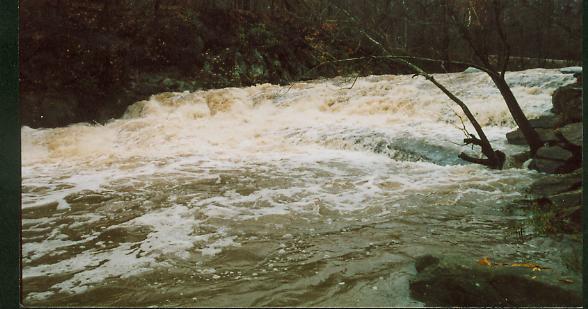
The put in is at Marriottsville Road at the Carroll County-Howard County line. Proceed from here with caution, for just a few hundred yards downstream lies McKeldin Falls, the largest single rapid on the Patapsco River. It's a solid class 4, quadruple-ledge drop that falls a total of about 12 feet over 20 yards. When the hills on river left become high and canyonesque, listen for it, and get out (river left) to scout. The portage is a wickedly steep climb up the hill/cliff on the left, and then around to a large pool at the bottom. For the experienced, a variety of routes can be used depending on water level, but beware of small sieves against either shore, and a very wide, flat, mildly undercut rock (usually submerged and creating a strange looking hydraulic) at the dead center of the river near the bottom. It looks as if it would love to eat the nice flat bow of a playboat.
From here, the river calms again for the next 3/4 mile to the confluence with the N. Branch Patapsco. There is no road access here, so you'd either need to enter the McKeldin area of Patapsco State Park and just run McKeldin Falls or paddle enother 2 miles of mostly flatwater to the takeout at Woodstock Road (steep climb out on the right) to the parking lot across from a roadside bar. Don't miss this high overpass: Daniel's Dam is the next best takeout, after a further five miles (of mostly flat water) downstream.
If you'd like to run just the McKeldin Falls, for a charge of $2.00 weekdays or $3.00 weekends, you can enter the McKeldin area of Patapsco State Park and follow the signs to the McKeldin Falls parking area to park and have a short carry directly to the Falls.
BTW: McKeldin Falls was created sometime between 1830 (when the B&O Railroad was started) and 1851 (when Howard County was created from a portion of Anne Arundel County) when the B&O railroad decided to cut through a loop in the S. Br. Patapsco. It was more convenient to move the river than to build two bridges. You can see evidence of this today, both on Google Maps or on the ground, as there is still a faint oxbow marking the original channel behind the railroad grade.
Waterfalls (1)
Hazards & Portages (1)
Caution: The following locations may require scouting or portaging. Always check current conditions.
Difficulty
Class I-III(IV)
Length
1.3 mi
Gradient
17 ft/mi
max 25
Rapids
0
1 Hazard
Access Points
Difficulty Classes
I Easy
II Novice
III Intermediate
IV Advanced
V Expert/Extreme
VI Unrunnable
Current Conditions
5-Day Forecast
Whitewater data from
American Whitewater
American Whitewater