4 - Middle - Old Hwy 441 to Tallulah Falls Lake
Linked via: Proximity 84% confidence Synced 6mo ago
Gauge Conditions
Runnable: 250.0 – 1,000.0 CFS
Data from American Whitewater & USGS
Run Map
Run Time Estimate
Select put-in and take-out to estimate time.
Unlock Advanced Trip Planning
See wind-adjusted speed maps, forecast planning, and detailed time estimates.
Sign in to generate an AI timing estimate for this run.
Whitewater timing varies with scouting, portages, and group pace. Use as a planning baseline.
Description
 On January 20th, 2002 a group of 11 boaters from the Atlanta Whitewater Club and the Georgia Canoe Association paddled a seldom run strech of the Tallulah river upstream of North Georgia's now famous Tallulah Gorge. Like the Gorge, this stretch is typically dewatered by an upstream dam and diversion tunnel. Only when strong rains bring up a large tributary is this section runnable.
In the fall of 2001 a group of Georgia boaters hiked the bypass reach, known as the Mathis Reach, with American Whitewater staff and volunteers. The group decided that with water, the section had potential as a beginner/intermediate paddling resource. Later that evening, American Whitewater met with Georgia Power and Georgia DNR and discussed the possibility of conducting a flow study on the Mathis Reach as part of the mandated review process for the Tallulah hydro license. Georgia power stated that there was no physical structure in the dam to provide releases so a flow study was impossible. We were still interested in studying the reach, since releases structures can be added at dams through relicensing.
It was decided that the most cost-effective and reasonable way to proceed was to offer to try to do a feasibility study with the limited natural flow from a tributary. It was agreed, and we contacted the boaters from the hike requesting that they attempt a descent this winter and document their experience with photos and a written report. On January 20th, after a heavy rain, they followed through on their promise.
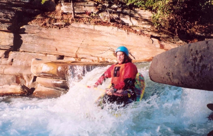
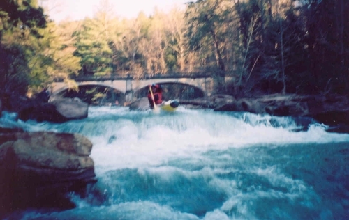
Their descent was a low water one, but gave them an idea of what the run is like. They described the first couple miles, from the dam to the first 441 bridge as "completely flat, and probably not worth doing, even with alot of water." The next section, between the two 441 bridges, was more fun with a couple of small Class II slides and shoals and a decent surfing wave. Between the second 441 bridge and the lake was a 1/2 mile section of Class III whitewater that provided some enjoyable challenge for the group.
The final recommendations from the group will be integrated with the rest of the information that we have on the Mathis Reach and the Tallulah license. Based on this information, American Whitewater will decide how to address the dewatering of the Mathis Reach and if it is feasible and reasonable to request releases in this reach.
We would like to extend a big thank you to all of the grassroots feasibility study participants:
todd shollenberger (organizer extraordinaire)
charlotte shollenberger
mike farrell
rob murphy
aimee murphy
alison lowry
john hudgens - oc-1
debra berry - oc-1
dustin smith
tom bishop
and Hayes.
Directions: This run is completely roadside, along what is called "Old 441" near the Tallulah Gorge. Driving north on US 441, cross the dam and look for a left across from the entrance to the Interpretative Center. Drive along this road and put in wherever you please, noting that the most action on this run occurs toward the very end of this run nearing the lake. Be wary around the RV park, though. The owner is NOT very supportive of whitewater boating on this reach.
Rapids in this Run (2)
Difficulty
Class II-III
Length
5.7 mi
Rapids
2
Access Points
Difficulty Classes
I Easy
II Novice
III Intermediate
IV Advanced
V Expert/Extreme
VI Unrunnable
Current Conditions
5-Day Forecast
Whitewater data from
American Whitewater
American Whitewater