Mill Creek to Dug Mountain Access
Eastatoe Creek -2, Lower Gorge
Linked via: Nhdplus discovery 90% confidence Synced 6mo ago
Gauge Conditions
Primary
Runnable: 75.0 – 10,000.0 CFS
Data from American Whitewater & USGS
Run Map
Run Time Estimate
Select put-in and take-out to estimate time.
Unlock Advanced Trip Planning
See wind-adjusted speed maps, forecast planning, and detailed time estimates.
Sign in to generate an AI timing estimate for this run.
Whitewater timing varies with scouting, portages, and group pace. Use as a planning baseline.
Description
Directions: From Keowee Toxaway State Park, go north on SC11. In about 3.5 miles, turn left on Roy F Jones Hwy. The take-out is about 1.2 miles down this road at the Dug Mountain Access Area, after passing over the bridge over Eastatoee Creek.
Shuttle Directions: Continue down Roy F Jones Hwy until it ends. Turn right on Cleo Chapman Hwy. Eventually, Cleo Chapman Hwy will parallel the river. After passing over Mill Creek, Mill Creek Rd enters from the left. Park in the road right-of-way between Cleo Chapman Hwy and Eastatoe Creek.
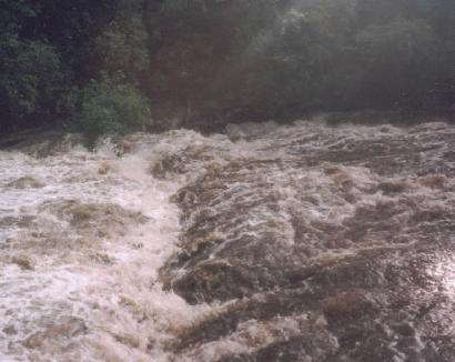
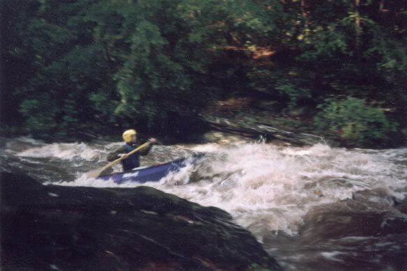
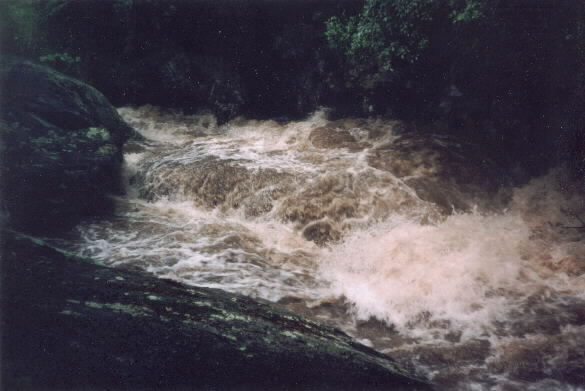
Local boater Brett Dalton has this to say "At the end of the valley "proper" (about 1/2 mile below Mill Creek and Mill Creek Road on Cleo Chapman Highway), the river enters the lower gorge. It begins with a pretty good bang when the water is up. There is one very constricted undercut slide that could be a killer in a kayak. Higher water is much better at this rapid. However at very high levels the water constricts against an undercut rock wall and shoots straight up in the air for 15 or 20 feet. At high water there are very few boulders or technical maneuvers required. Of course it is narrow and requires frequent maneuvering, just no must make ferries or anything. _(After the first rapid this run is a nonstop flush of class III whitewater. There is one large slide but the remainder of the run is wave trains and big holes. Will Reeves describing a high water run)._
This excitement continues for several miles until you come to Dug Mountain Bridge on Roy F. Jones Highway. This is the best takeout as there is a designated parking area.
Below Dug Mountain Bridge there are a few more minor slides and good currents for 1/2 mile or so. Following this initial 1/2 mile, the river becomes very gentle again as it approaches Lake Keowee. Near where the river enters Lake Keowee, Little Eastatoee Creek comes in from the left. The river never really "dumps" in the lake, it almost becomes the lake. There was a take out on the side of the road on Cleo Chapman Highway, but now the Cliffs at Keowee Vineyards exists and parking on the road is no longer an option. You pretty much have to paddle all the way over to HW 11 bridge. The section of the creek below Dug Mountain Bridge is no longer worth paddling because of the development and the long long paddle around the shore of Keowee."
I would imagine that at low water this run is a class II creek with one big class IV+ rapid involving a big undercut and ledge.
Rapids in this Run (2)
Hazards & Portages (1)
Caution: The following locations may require scouting or portaging. Always check current conditions.
Difficulty
Class II-III(V)
Length
2.8 mi
Gradient
60 ft/mi
Rapids
2
1 Hazard
Access Points
Difficulty Classes
I Easy
II Novice
III Intermediate
IV Advanced
V Expert/Extreme
VI Unrunnable
Current Conditions
5-Day Forecast
Whitewater data from
American Whitewater
American Whitewater