Route 113A to Tamworth
Linked via: Proximity 40% confidence Synced 6mo ago
Gauge Conditions
Runnable: ? – ? CFS
Approximate reading: This gauge is 4.3 miles away on Wonalancet. Use as a general reference only.
Data from American Whitewater & USGS
Run Map
Run Time Estimate
Select put-in and take-out to estimate time.
Unlock Advanced Trip Planning
See wind-adjusted speed maps, forecast planning, and detailed time estimates.
Sign in to generate an AI timing estimate for this run.
Whitewater timing varies with scouting, portages, and group pace. Use as a planning baseline.
Description
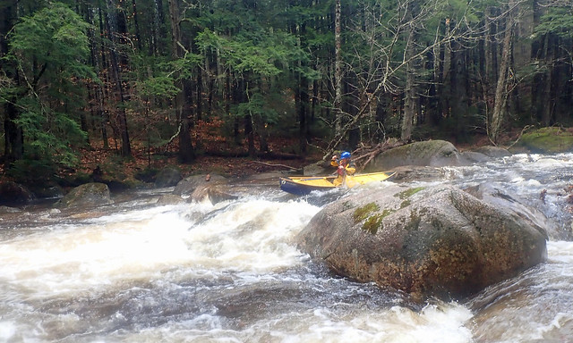
The Wonalancet is one of those mountain streams that rarely comes up, but when it does it provides the best introduction to creeking Class III river in all of New Hampshire. The river drains Mount Wonalancet and Mount Chocorua on the southern edge of the White Mountains (on the opposite sides of those mountains from the Mad and Swift Rivers). It flows through Hemenway State Forest and some very peaceful and lovely wilderness landscapes. Eventually it empties into the Bearcamp, and from there into the Saco. It is only runnable during the spring snow melt and periods of high runoff, rising and falling quickly, usually in a day or two. As a result, it is seldom run. If you are lucky enough to catch it up, be on the lookout for the numerous strainers that are common.
This river is listed on old maps as the Swift River. However, to avoid confusion with the better-known Swift River to the north, the paddling community refers to it by the name of its upstream section, the 'Wonalancet'. So don't be confused by any signs referring to the 'Swift River.'
There are multiple put-in and take-out's on the river, allowing paddlers the flexibility of tailoring their trip to paddler ability, interest, water level and time. The run can be as short as 2-1/2 miles or as long as 5-1/2 miles.
At a level of 0.3 (medium low) the river is an easy technical Class III. The numerous drops require good paddling skills to stay in your boat and avoid the rocks. However, a swim at this level is forgiving. At a level of 1.0 most of the rocks disappear; however, the river still has plenty of eddies and is not yet pushy and strainers may add to the challenge of the river, requiring good setting and eddy-turn skills. At a level of 2.0 the river becomes pushy, paddlers must pay attention and be ready to react quickly to rocks, holes, and strainers. At higher levels a swim could be dangerous due to the numerous strainers across and in the water.
### Upper Section
The upper section starting at the second Route 113A bridge is narrow and lower volume than the lower sections since it is above several of the main feeder streams. In terms of difficulty the upper section is similar to the lower; it starts out with a set of busy class III rapids then settles down to continuous class II rapids with the occasional class III drop. This upper section requires approximately 6 inches of more water then the lower sections (as measured on the paddlers gage).
### Middle Section
The middle section begins where the Wonalancet merges with Paugus Brook just upstream of the first Route 113A bridge north of Tamworth. Put on at the Fowler's Mill Road bridge (also known as Chocorua Mountain Road). Plenty of parking here and the most common put-in. A long delightful class III rapid is encountered immediately starting where Paugus Brook flows into the Wonalancet. Below the rapid is the first Route 113A bridge; the painted gauge is here, on the river right bridge abutment. Individuals wishing a short warm-up time before running the rapids may put in here.
The next half-mile is continuous Class II with several easy Class III sections as the river enters the state forest.
The most challenging area is the Forest Run Rapids in the middle of the section. This is an important spot to scout to check for wood in a blind corner Class III drop just after the foot bridge that leads to the fire tower. Below Forest Run Rapid are three more longish class III rapids before reaching the upper take-out, a place where the roadsid comes into clear view and the banking is less steep. There is a small parking strip that can handle a half-dozen cars, dependent on snow cover.
### Lower Section
The lower section is a mixture of class II and III rapids. There are some mid-river islands to choose a left or right passage, follow the main current and watch for strainers around blind corners. Close to town of Tamworth the river settles down to a gentler Class II. As the river approaches the town, Tamworth Falls, an abrupt class III drop appears. The drop is blind so scout it for strainers. Below Tamworth Falls are more class II/III rapids that end as the river enters the town.
Take out at the paved public parking lot just past the Tamworth Inn in the center of Tamworth.
### Extension Trip Options
#### Upper Upper Section - Class IV
The upper section (the actual Wonalancet) is boatable as well. Put on here in the town of Wonalancet where the river (a small brook at this point) crosses under a road branching off route 113A (43.9085N/71.3510W). This section is 3.8 miles long and has a gradient mile-by-mile of 100 (0.8 mi.), 140, 100, 20, and is reported to be a Class IV steep creek. Boaters who have run this section report it as being full of strainers as well. If you run this section, please provide feedback to the streamkeeper.
#### Paugus Brook - Class II
Paugus Brook, which flows into the Wonalancet at the lower put-in's is likewise boatable. Primairly class II with one short but exciting class III section half-way down. This class III area is narrow with tight turns and frequently collects strainers so be aware. Paugus Brook runs 1 mile down to the Wonalancet, with a drop of 55 feet.
#### Lower Lower - Class I-II
For a relaxing trip, you can run the river from the take-out in Tamworth all the way down to the Bearcamp River along route 25 (43.8277N/71.2421W). This quickwater section is 3.3 miles long. A convenient put-in/take-out is located after the first mile, where the river goes under Route 113 (43.8471N/71.2654W). Past Route 113 there are several small dams requiring portages plus numerous strainers as well as the occasional beaver dam.
Rapids in this Run (15)
 Rapid
Rapid
Paugus Brook Put-in
Rapid
III
First Quarter-Mile
Rapid
III
Upper Section
Rapid
Fowlers Mill Road Put-in
Rapid
Paugus Brook Rapid
Rapid
Route 113A Bridge Put-in.
Rapid
II+
Middle Section
Rapid
III
Forest Run Rapid
Rapid
Trail Bridge
Rapid
III
Unnamed Class III
Rapid
III
S-Turn
Rapid
III
Rapid above Short Run Take-Out
Rapid
Short Run Take-Out
Rapid
II+
Lower Section
Rapid
III
Tamworth Falls
Difficulty
Class III
Length
4.1 mi
Gradient
67 ft/mi
Rapids
15
Access Points
Shuttle Info
### Take-Out
From the north or south, drive along Route 113 to the town of Tamworth and the intersection of routes 113 and 113A. Drive thru to the end of the downtown area; the take-out is a public parking area on the left just past the Tamworth Inn.
### Short Run Take-Out
From Tamworth and the intersection of routes 113/113A, drive north along Route 113A about one-and-a-half miles. There is a small pull-off on the left with a climb up a steep bank from the river.
### Scouting Access
Best place to scout the river is either from the State Forest Trail. The trail head is well marked with a pull-off about two-and-a-half miles up route 113A from Tamworth. Walk into the river where the bridge crosses over the Forest Run rapid. There is also good access to the bottom of Forest Run a quarter-mile south along the road by another roadside pull-off.
### Gage Bridge (First Route 113A Bridge)
The first Route 113A bridge is about three miles from the Route 113/113A intersection in Tamworth.
### Middle Put-In – Fowler's Mill Road Bridge
From the first Route 113A bridge, drive a very short distance up Route 113A, turn right on a dirt road, and put in where the river runs under the road at 43.89466N/71.29681W.
### Upper Put-In
Pass over the river at the first Route 113A bridge; continue north along Route 113A about another mile to the second bridge over the river. There is parking for only about three cars here on the left.
### Paugus Brook Put-In
From the middle put-in on Fowler's Mill Road (also known as Chocorua Mountain Road) approximately 1-1.5 miles where it crosses Paugus Brook at 43.9080N/71.2895W.
Difficulty Classes
I Easy
II Novice
III Intermediate
IV Advanced
V Expert/Extreme
VI Unrunnable
Current Conditions
5-Day Forecast
Whitewater data from
American Whitewater
American Whitewater