Thorpe Dam to Thorpe Powerhouse on Tuckasegee Reservoir
Linked via: Nhdplus gnis 95% confidence Synced 6mo ago
Gauge Conditions
Runnable: ? – ? CFS
Approximate reading: This gauge is 5.9 miles away on Tuckasegee. Use as a general reference only.
Data from American Whitewater & USGS
Run Map
Run Time Estimate
Select put-in and take-out to estimate time.
Unlock Advanced Trip Planning
See wind-adjusted speed maps, forecast planning, and detailed time estimates.
Sign in to generate an AI timing estimate for this run.
Whitewater timing varies with scouting, portages, and group pace. Use as a planning baseline.
Description
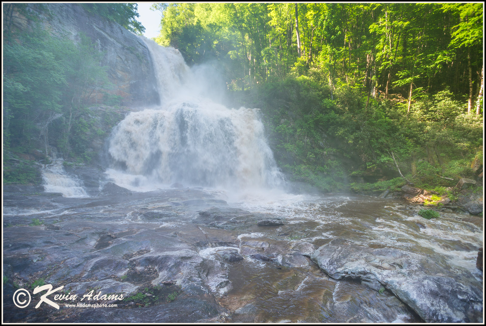
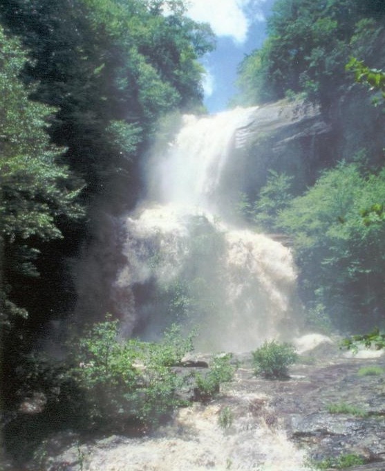
The West Fork Tuckasegee Gorge is currently a wild and beautiful, but woody place. Hike in on the incredible trail built by Duke Energy that starts in a well-signed parking lot just across the dam from Highway 107. You'll hike past a memorial plaque for Charles Paul Horner, whose memorial fund helped American Whitewater to establish and negotiate the trail route. Don't get lured into putting on before the trail ends at the base of the massive double drop known as High Falls or Cullowhee Falls. Put on too soon and you could risk going over one of two big unrunnable drops.
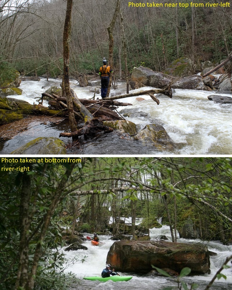
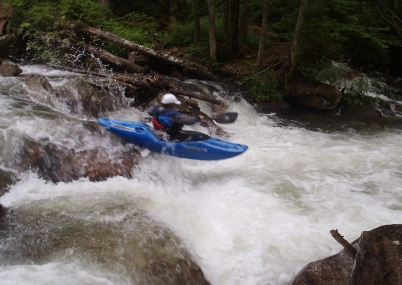
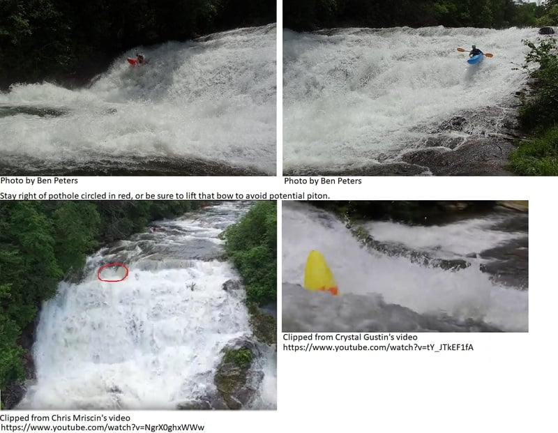
At the put in, amidst the spray and wind coming off High Falls, you will have a choice: Either paddle across the river and hike around the first two challenging Class IV/V rapids, or run them. Note that the entire run below the put in is private property. After the two entry rapids (and some wood) the river mellows and flows through small rapids until a house comes into view on river left, and an obvious horizon line appears. This is the first of three small sloping ledges that lead to the hallmark drop of the run, Breakbone Falls, a 25 foot slide on the left called Crash Landing and a three-tier sloping-then-vertical drop on the right usually called Flight Simulator or Fright Stimulator. The left side is run well left of center. The right side is run only a few feet off the right bank. Note that at least two people have suffered significant back injuries on this slide, and scouting the left side is extremely difficult.
Small rapids (and strainers) continue until you come to two houses on the stream bank on river left. Both homeowners are very concerned about trespassing, so please be respectful. The river bends sharply to the right immediately after passing the houses and offers a nice 4 foot boof a couple feet off the left bank. There is a rock in the landing but a good boof should make for a soft enough landing. If you scout this drop, stay in the streambed and respect private property.
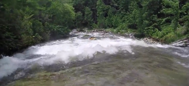
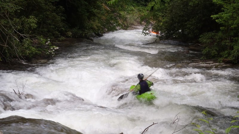
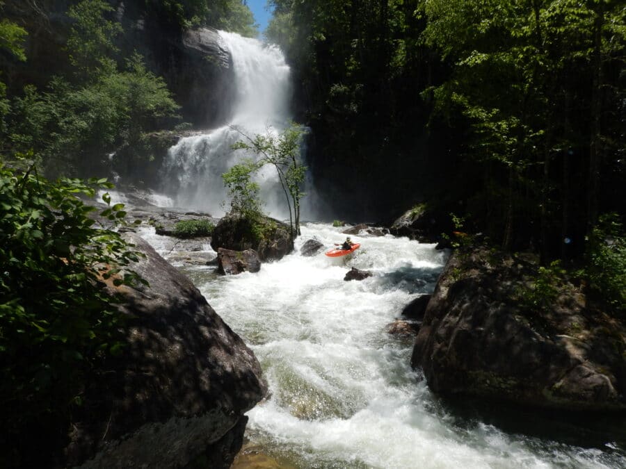
The river continues at this Class II/III pace for nearly a mile. When you see a small house on the right just above the river, you'll know the river is about to drop over a series of slides. These aren't as steep or tall as the earlier big slide, Breakbone Falls, but they are quite a bit of fun. You can catch a small eddy on river right above the first one to scout. The first of these slides (Kornegay's Cascade) is the biggest, probably 15-20 feet of total drop. The preferred current line starts left of center and moves right down the slide to the bottom. The other slides are smaller and easy to scout from your boat.
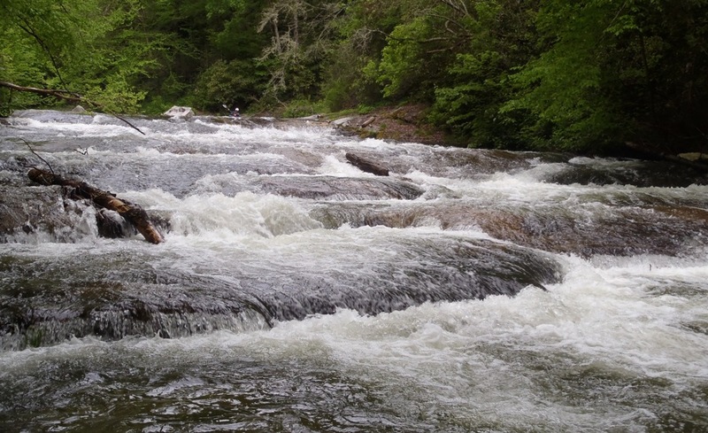
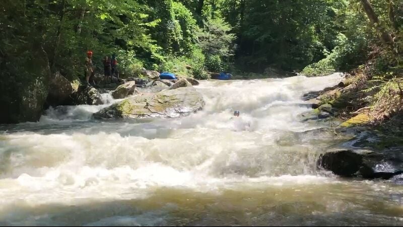
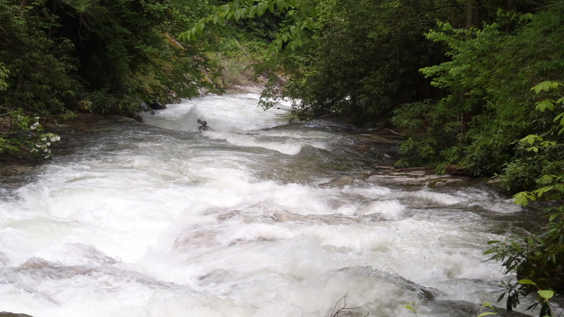
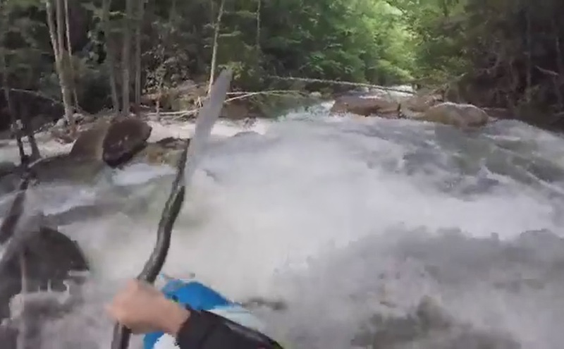
These slides will continue until you pass under Cullowhee Forest Bridge (a private road with no public access), at which point the river changes character dramatically. A nice slide indicates you are almost to High Turnover, the crux of the run. High Turnover boasts a lead in wave/hole followed by a vertical ledge hole, followed by a sloping ledgehole that can dish out some surfs at the right flow. More cool bedrock rapids continue for a while as the river flows through a small mini-gorge before the run opens up. Once it opens up it stays pretty mellow to the takeout at the bridge near the Tuckasegee Powerhouse.
The West Fork offers paddlers a couple of complex boulder garden Class IV/V rapids at the put-in, a big slide, several smaller slides, a standout class IV mini-gorge, and many other class III rapids. Be aware that this entire run below the put in flows through private property - travel respectfully.
Put in: Drive across the spillway and dam to a wide turnout – parking area on the right at the west edge of the dam. The recommended put in is downstream of High Falls, about 8/10 of a mile below the dam, at the terminus of the well marked trail. DO NOT PUT IN ABOVE HIGH FALLS.
Take out: There is a parking area on Hwy 107 next to the powerhouse. The shuttle is 7 miles exactly. Duke Power has built a walkway from the takeout bridge to the parking area.
Rescue Protocol: Someone who is injured and needs to be assisted off the river from the private land needs to call the Glenville Rescue Squad at 828.743.3655. They will come in with access to the private land gates (Cullowhee Forest has multiple gates, not just the one at Hwy 107) and remove and/or transport an injured paddler to care.
Release History: On June 29, 2001, American Whitewater organized a team of volunteers to run this dewatered reach as part of a whitewater flow study. We found a super fun creek run of moderate difficulty with one big drop and tons of great low angle slides and boulder rapids. We signed a settlement agreement with Duke Power and other stakeholders in 2003 recommending 7 annual releases, which were expected to begin in 2006. Delays associated with the removal of Dillsboro Dam have prevented the new releases from becoming a reality. FERC licenses were issued in 2011, and 2013 became the magic year when releases began.
Gauge and Flow: A very useful stick gauge is located across Hwy 107 from Thorpe Powerhouse. It is located underneath the upstream side of the metal bridge, bolted to a boulder next to the bridge's foundation on river-right and facing downstream. The gauge measures level in feet and tenths of a foot. Much of the river feels like class III with a few class IVs when the water is bouncing between 2.6ft and 3ft on the stick. The river's class IV rapids remain class IV down to 2.4ft or even 2.2ft. However, 2.4ft makes the river's class II/III slides very scrapey, and turns its class III rapids into mostly class II+. Running the harder stretches is not advised for typical class III boaters when water is hitting 3ft on the gauge. The first two rapids of the class IV mini gorge (The Crux and Center Boof) are frightening at 3ft and higher. However, the last two rapids (which merge into one at 3ft) are stiff but manageable class IV as high as 3.3ft, and the Two Mile Runout is a class III+ romp at 3.3ft. Scheduled releases are intended to be 250cfs, which corresponds to water bouncing between 2.4ft and 2.6ft on the stick gauge across from Thorpe Powerhouse
Duke Energy links messages about unscheduled and scheduled releases into the WFT gorge on its "Nantahala Lake Levels" page ( http://www.duke-energy.com/lakes/nantahala/nantahala-lake-levels.asp). Just look in the last column of Lake Glenville's row. If there's a date, click it to open a page that has announcements about releases from the lake into the WFT gorge.
Two web pages can be used together for a usually reliable "online" way to know if there's water in the WFT gorge:
a. USGS 03508050 TUCKASEGEE RIVER AT SR 1172 NR CULLOWHEE, NC
(http://waterdata.usgs.gov/nc/nwis/current/?type=flow)
b. Duke Energy's Power Generation Schedule on EFT and WFT:
(http://www.duke-energy.com/lakes/nantahala/nan-scheduled-flow-releases.asp)
There is **probably water in the WFT gorge if \*any one\* of the four following conditions is met**.
1\. At least 250cfs at the SR1172 gauge (link "a" above) AND \*no\* power generation on the WFT or EFT (link "b" above).
2\. At least 500cfs at the SR1172 gauge (link "a" above) AND power generation on the WFT but not on the EFT (link "b" above).
3\. At least 750cfs at the SR1172 gauge (link "a" above) AND power generation on the EFT but not on the WFT (link "b" above).
4\. At least 1000cfs or more at the SR1172 gauge (link "a" above) AND power generation on both forks (link "b" above).
These "rules-of-thumb" are based on three facts:
1) Power generation on WFT through the Thorpe Diversion Pipe adds around 250cfs at the SR 1172 gauge.
2) Power generation on EFT through Cedar Cliff's powerhouse adds around 500cfs at the SR 1172 gauge.
3) Releases through Thorpe Dam's gate are typically close to 250cfs.
Two glitches in these "rules-of-thumb" I can think of are 1) the rare circumstance when Duke opens Cedar Cliff Dam's flood gate, adding more water to EFT than the electricity-generating release, and 2) when Duke reports releases into WFT (link B) that aren't through the Thorpe Diversion Pipe.
Kevin Colburn's story about the flow study pdf. Note that the second flow referred to in this story as "350cfs" was determined later to have actually been 250cfs. This optimal flow will be the one provided by releases starting in 2013.
You can view the 2001 Flow Study video of the event on youtube. You can also download Leland's 9.5-minute video of the event. Choose Small version (240 x 160, 69.3 MB) or Large version (360 x 240, 168.8 MB).
Rapids in this Run (12)
 Rapid
IV
Rapid
IV
Debris Field (aka, First Boulder Garden)
Rapid
III
Trailside Stretch
Rapid
III
Lead-in Ledges to Breakbone Falls
Rapid
III
Residential Stretch
 Rapid
III+
Rapid
III+
Kornegay's Cascade
 Rapid
III
Rapid
III
Cullowhee Forest Bridge
Rapid
IV
Mini Gorge (general description)
 Rapid
IV
Rapid
IV
Mini Gorge's First Rapid: High Turnover (aka, The Crux)
 Rapid
III+
Rapid
III+
Mini Gorge's Second Rapid: Center Boof
 Rapid
IV
Rapid
IV
Mini Gorge's Third Rapid: Crevice Ledge (aka, Lumpy Ledge)
 Rapid
III+
Rapid
III+
Mini Gorge's Fourth Rapid: Swirly Gneiss
Rapid
III
Two Mile Runout
Waterfalls (3)
Hazards & Portages (5)
Caution: The following locations may require scouting or portaging. Always check current conditions.
Difficulty
Class III-IV+
Length
5.6 mi
Gradient
143 ft/mi
Rapids
12
5 Hazards
Access Points
Difficulty Classes
I Easy
II Novice
III Intermediate
IV Advanced
V Expert/Extreme
VI Unrunnable
Current Conditions
5-Day Forecast
Whitewater data from
American Whitewater
American Whitewater