Town Creek Road to Copper Mine
Tesnatee Creek
Linked via: Unknown Synced 6mo ago
Gauge Conditions
Runnable: 600.0 – 2,000.0 CFS
Data from American Whitewater & USGS
Run Map
Description
Sources: A Canoeing and Kayaking Guide to Georgia, S. Welander, B. Sehlinger and D. Otey (2004); Northern Georgia Canoeing, B. Sehlinger and D. Otey (1980).
Tesnatee Creek is a major tributary of the Chestatee, located mostly in White County. The last mile or so is in Lumpkin County and the confluence of the Tesnatee and the Chestatee is less than a quarter mile below the Chestatee's Grindle Falls.
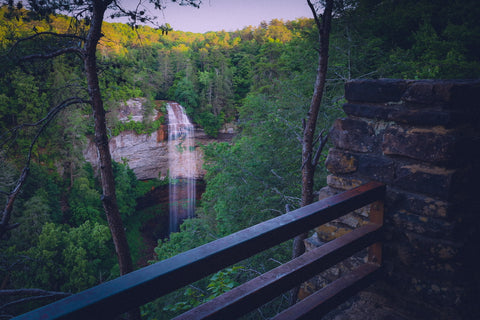
The Tesnatee makes for a pleasant day trip with Class I-II rapids and one portage around a dam and Class IV Testnatee Falls. Like most north Georgia streams, the Tesnatee is experiencing an increase in housing and a decrease in nature along its banks. There is still plenty of forest, however, along with occasional 20-30 foot rock walls.
The navigable portion of the Tesnatee is generally considered to begin at Town Creek Road in White County. When the water is high (probably above 850 cfs or so), an additional 1.8 mile section above Town Creek Road becomes runnable. To reach this higher section, turn off Town Creek Road onto Charlie Thomas Road about 200 yards east of the Town Creek Road Bridge. Charlie Thomas Road parallels the creek and ends at Testnatee Gap Valley Road. The creek can be accessed at the culvert/bridge or just upstream of the culvert/bridge from the field road on river left.
The usual put-in is at Town Creek Road: the gold and gem business on river right just upstream of the bridge will generally permit parking, but make sure to ask permission. (Note: this is NOT the same Town Creek Road that accesses the Chestatee in Lumpkin County.)
The next potential access is at Gene Nix Road, 2.1 miles downstream of the put-in. The area surrounding the bridge at Gene Nix Road has seen a lot of recent development, however, so available parking is minimal. Property owners near the bridge are not thrilled about boaters on the river. Access at Gene Nix Road should generally be limited to drop-and-drive.
The last potential access before the Chestatee is from Sandy Ford Road where it parallels the creek just east of the Lumpkin County (paved)/White County (unpaved) line. The bank is short but steep and there is parking for only 2-3 vehicles. There is no access below this point on the Tesnatee or on the Chestatee between the confluence and Copper Mine.
The take-out is either above or below Copper Mine, a Class III+ rapid on the Chestatee. For information on Copper Mine rapid and the take-outs above and below it, see AW reach #3388, Chestatee River - Town Creek Church Road to Copper Mine.
The major hazard on the Tesnatee, the dam and Tesnatee Falls, are 3.6 miles from the put-in or 1.5 miles downstream of Gene Nix Road. The dam is quite obvious from the sound, the concrete walls extending into the creek from both banks and the refurbished generator building just beyond the dam on river right. Tesnatee Falls, which Welander, Sehlinger and Otey call "a 20-foot drop" but which looks smaller to me, is not a true falls but rather a steep, rocky slide. It is located just below the dam.
Except for the most experienced and gonzo of boaters, the dam is a mandatory portage. Anyone choosing to run the dam should scout from the right bank and avoid the vertically pinned log near the center of the creek.
If you want to avoid both the dam and Tesnatee Falls, portage on the right bank. The property is private, so please do not litter or cause any damage: if the owner closes the portgage, it will effectively close the creek to most boaters.
To avoid the dam but run Tesnatee Falls, Welander, Sehlinger and Otey recommend scouting from the right bank and portgaging on the left. When running the falls, avoid the rock outcropping on river right.
River right at the dam and Tesnatee Falls used to be known as "Hobbit Land" because of the dilapidated buildings, including the generator building. The generator has now been refurbished, the other buildings torn down and the area cleaned up by its private owner. Please respect his property and especially stay away from the generator building and the bridge accessing it.
CAUTION: the generator will be going back into service in the near future and, when it does, will draw water through a diversion pipe beginning just above the dam on river right. There is no way of knowing how much suction will be created at the top of the diversion pipe. The pipe is screened, but could still be dangerous if the suction proves to be significant. Boaters portgaging or scouting river right should take out well upstream of the screen.
DIRECTIONS:
From Atlanta, take Highway 400 north until it ends. Continue north on Long Branch Road, through the stop-lighted intersection with Highway 52. About a mile past that intersection, you will see the bridge over the Chestatee. To scout Copper Mine rapid and the take-out, park along the road and go down on the south/river left side of the river: a path leading downstream will take you to the abandoned gold mine, the old bridge, Copper Mine rapid and to take-outs before and after the rapid.
To reach the put-in, continue north until the road ends at Cavender Creek Road. Turn right and continue on Cavender Creek Road until it ends just after a one-lane wooden bridge (Grindle Bridge over the Chestatee). Turn right - there is no street sign, but you are now on Dugas Road. The road will change from pavement to dirt at the Lumpkin/White County line and the name will change to Sandy Ford Road. Stay on Sandy Ford Road until it ends at Town Creek Road. Turn right on Town Creek Road and the put-in is on the left in about .6 mile, just before the bridge over the creek.
From Cleveland, take Highway 115 west. About 1.7 miles from the square, turn right on Town Creek Road. (As the sign at the intersection warns, drive carefully - the road is hilly, curvy and busy.) You'll cross Tesnatee Creek in about two miles: the put-in is at the business on the right just after the bridge.
To reach the take-out, continue on Town Creek Road about .6 mile and turn left on unpaved Sandy Flats Road. Sandy Flats Road will become Dugas Road and will become paved as you cross into Lumpkin County. After a mile or so of paved road, turn left onto Cavender Creek Road and cross the one-lane wooden bridge. After a half mile or so, turn left onto Copper Mine Road. You'll reach the river in just under a mile. Parking is roadside and the path downstream to the rapids, etc. begins under the south/river left side of the bridge.
Rapids in this Run (4)
Waterfalls (1)

Playspots (1)
Hazards & Portages (2)
Caution: The following locations may require scouting or portaging. Always check current conditions.
Difficulty
Class I-II(IV)
Length
9.4 mi
Gradient
25 ft/mi
Rapids
4
2 Hazards
Access Points
Difficulty Classes
I Easy
II Novice
III Intermediate
IV Advanced
V Expert/Extreme
VI Unrunnable
Current Conditions
5-Day Forecast
Whitewater data from
American Whitewater
American Whitewater