* UPDATE 2025.09.05 Sketchy wood, but doable * Conservancy to S.Wisconsin St. (1.18 mile or 0.3 mile PnH)
Linked via: Proximity 97% confidence Synced 6mo ago
Gauge Conditions
Runnable: 200.0 – 750.0 CFS
Almost certainly too low (but you could check its stick-gauge for possible low-water minimums). (Stick-gauge under 13.9' is a total scrape.)
Data from American Whitewater & USGS
Run Map
Run Time Estimate
Select put-in and take-out to estimate time.
Unlock Advanced Trip Planning
See wind-adjusted speed maps, forecast planning, and detailed time estimates.
Sign in to generate an AI timing estimate for this run.
Whitewater timing varies with scouting, portages, and group pace. Use as a planning baseline.
Description
Quick Facts:
Location: Port Washington, WI.
Put-in Parking: 43.39465 -87.88230 (Sauk Creek Nature Preserve)
Take-out Parking: 43.38634 -87.87241 (S.Milwaukee St.)
Shuttle Length/DriveTIme: 1.1 miles/3 minutes.
Gauge Info: Linked gauge is only an *indicator* of *possible* water in the area. The only reliable gauge is the PLATE GAUGE at Grand Avenue bridge (upstream river-right):
< 14.0' is not recommended, 14.0'-14.5' is low (scrapey, but doable), 14.5'-15.5' is moderate, 15.5'-16.5' is high, and >16.5' is very high.
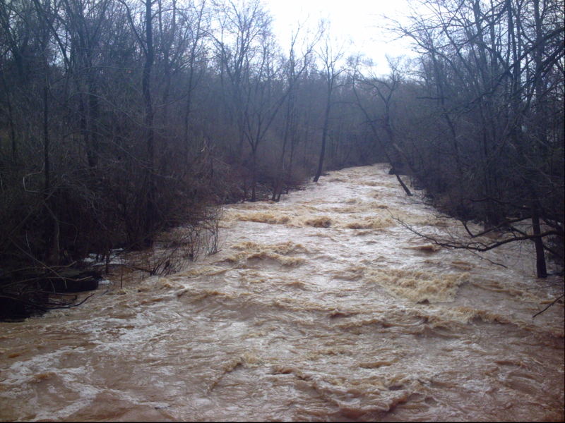
This has been run with the entire plate gauge submerged, later measured/approximated at 17.3' ... it was an amazing, wild, runaway-freight-train rush!
IF PLATE GAUGE IS SUBMERGED, do not put on without checking the 'Three Bar Bridge' (above Krueger Falls) for clearance!
Put-in elevation is approximately 660'
Take-out elevation is approximately 591'
Total drop is approximately 69'
10/85 Gradient Upstream of Put-in: 6 fpm
Percent Developed Upstream of Put-in: 6.6 %
The higher the above two values, the 'flashier' the stream will be. (These are not high values.)
However, the drainage area is small, so flows will not hold up more than a day or so at a time.
Drainage area at put-in: 30.4 square miles
Drainage area at take-out: 32.3 square miles
Drainage increase: 6.3%
Class/rating is NEVER enough to decide if you should run a river/rapids! Far more important than gradient and class/rating should be other less-quantifiable 'character factors': continuous versus pool/drop, wide-open routes versus constricted technical rapids, wide-channel (with multiple routes) versus narrow channel (with essentially one route), gradual river banks versus rocky shores or steep-walled gorges, et cetera.
Character:small creek, narrow, steep banks, continuous (especially at higher flows), bedrock channel then concrete debris finally cobble/gravel channel
River banks: generally steep banks, heavy trees/shrubs, rocks and concrete slab debris, etc.; Exit from river can be problematic especially at high flows.
Typical width: 20-40 ft.
Longest rapids (at normal/usual, low-to-moderate flows): 0.25-0.5 miles.
Longest rapids (at higher flows): 0.5-1.0 miles.
NOTE: The last two above are an attempt to represent if a boater were to capsize and swim at the start of the rapids, the distance the swimmer's errant boat and paddle are likely to travel.before one or two paddling companions might be able to corral the gear ashore. Obviously highly subjective!
NOTE: Other sources may show differing values (for gradient, class/rating, elevations, total drop, etc). Diifferences (up to 10-20% and more) generally mean very little in the grand scheme of all things whitewater! All values should be merely for general comparative purposes.
Recommended 'Companion Runs'
\------------------------------------------- Approximate ----- Approximate
\------------------------------------------- Distance ---------- DriveTime
Milwaukee River in Grafton ----------- 8 miles --------- 14 minutes
Cedar Creek ----------------------------- 11 miles --------- 18 minutes
Menomonee in Menomonee Falls --- 26 miles --------- 35 minutes
General Overview
Refer to 'Flow' tab for crucial info regarding gauge and flows!
Open canoes (without floatation bags) and 'recreational' kayaks (with no spray-skirt, or with flimsy nylon splash-skirt) are *not recommended* on this run!
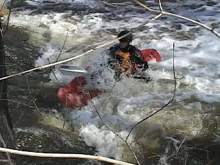
If you don't know how to back-paddle, sweep-stroke, or catch an eddy (or don't know what any of those mean), if you can't turn your boat 180-degrees with just one paddle stroke, it is really unsafe for you consider running this creek! At any level above 14.2' you are very likely to end up out of your boat, you are likely to lose your paddle and likely your boat as well. Do not take this run lightly!
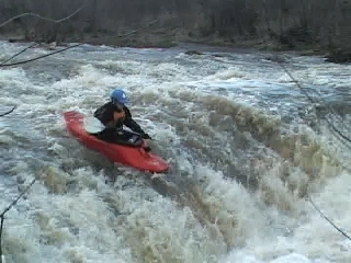
This run can be hard to catch at good levels (often runnable only a day or two at a time, but sometimes (in late spring or early summer) having a window-of-opportunity of only hours). It is a very interesting local change-of-pace when it is up. About 30' of drop in 0.3 mi (equivalent to near 100 feet per mile!) over bedrock and rocky rubble bottom provide an interesting 'creeky' feel, with sliding drops and *very little* play potential.
From the recommended put-in, you will have a short warm-up paddle (and likely some overhanging branches or wood in the water -- be careful!). There may be a few small waves for some minor surfs. As you reach an old bridge (now just three iron beams spanning the river overhead), the gradient will increase as the bedrock drops away toward the 'falls'. As the creek heads toward the falls, unfortunately it widens, so water sheets thinly across the bedrock.
At most water levels, you will be slowed by contact with the riverbed (raking/rashing the bottom of your boat) as you approach this 4' drop. The landing zone off the center of the drop is quite shallow (can cause boat or body damage), so the recommended route is generally down 'ramps' to either side. If you run the middle, hitting a 'boof' would be highly advisable, but is difficult since you are pitched down (on the sloping approach) and since the water will sheet so shallow across the approach that your speed is slowed, and it is tough to get a solid stroke to launch your boof. Be aware there is a transverse 'trench' in the bedrock left-and-center in the pool, which could dish out a major piton if you land 'nose-down' into it.
Immediately downstream, a series of short ledges, waves, and possibly playable holes (not great play, just possible play) will be found both upstream and down from a footbridge.
The Sauk Creek Nature Preserve is 27 acres of conservancy area (I.E., a park) with trails in a wooded tract on N.Moore Road. (Lat/Lng coordinates 43.3946 -87.8823) Locals have told me this is Kreuger Falls or Krueger's Falls (after the former owner of the property, before it was deeded over as a conservancy). Remnants of the foundations of old farmstead buildings can be found back among the trees on the property.
Boaters may wish to just do a 'park-and-huck' here, as this is the area of best gradient and most 'fun potential'. Generally you will carry upstream (short carry to somewhere above the falls and the 'Three Bar Bridge'), or a carry of 1/3rd mile (to the limits of the conservancy, where the main path turns sharply right/east, and you see denser trees and evergreens).
It is possible to eddy-out under the pedestrian bridge to get out and repeat a run of the steepest gradient (Krueger Falls), but you will probably wish to continue downstream, under Pierre Drive road bridge, to take out river-left alongside the high school athletic fields (where the banks are more reasonable for a climb out) and then carry upstream on sidewalks and roadside to your vehicle at the conservancy roadside parking.
As you proceed downriver, gradient eases, but continued areas of riffles and rips will be found. Large, sharp-edged, broken concrete slabs, boulders, old parking-meter posts, ever-changing strainers, and other debris litter the riverbed. You don't even want to think about flipping, swimming or trying to stand anywhere on this river when it is at runnable levels. Therefore, novice whitewater boaters should not run this river unless accompanied by an experienced paddler. Flips or 'out of boat' experiences are likely to be brutal! (All that said, I have long and often heard rumors of 'tons of rebar' in this river. I have walked most of the stream at minimal flows. While I cannot say that there is NO rebar, I would say that it is really quite sparse. However, the concrete slabs and other very shallow rock and debris are, indeed, quite plentiful.)
Most of the remainder will be little more than a swiftwater float, though one or two waves near the listed take-out may provide minor additional play. At high water (14.5' or more on the stick gauge), most of the run will be a rush of currents and waves, making the full run a hoot! From the pedestrian bridge (below the big drop) down to S.Milwaukee Street is a full mile, initially class III and soon dropping to a fairly continuous class I-II bobble.
Caution: Very alert, aware boating is required in the lower part of this reach, as strainers are extremely likely, change yearly (and sometimes monthly or weekly!) and can be deadly. (They are the most potentially dangerous thing about this run!!!)
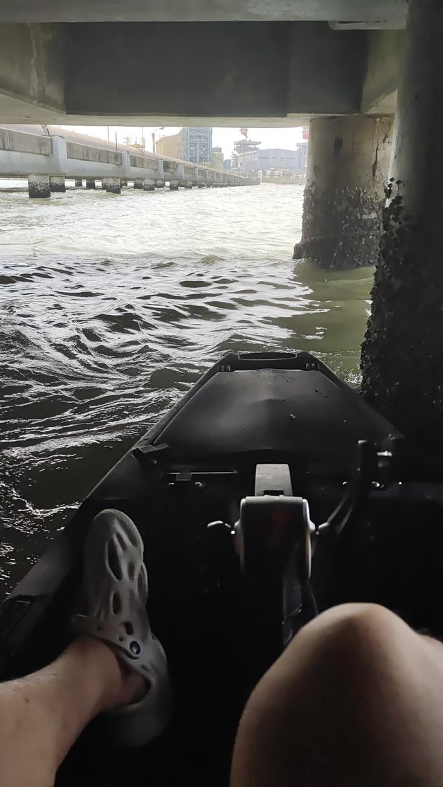
It is highly recommended that you get out no later than S.Wisconsin Street, before dropping into the lake and the harbor. A vertical steel-plate weir and outflows from a power plant create some wild currents (and potentially deadly hydraulics), especially at good boatable flows. In addition, scores of fishing lines are likely to hang from the platformed rim surrounding this area.
NOTE: The aforementioned weir has been broken out a bit, diminishing the dam/hydraulic at the mouth. This is also highly affected by Lake Michigan water levels. Some years back while the lake was at near-record-lows, there was more drop and more hydraulic! Since then lake levels have been higher, and there is almost no drop and no noticeable hydraulic, however fishermen and outflow from the powerplant are still likely to be problematic.
Rapids in this Run (7)
Waterfalls (1)
Playspots (4)
Hazards & Portages (4)
Caution: The following locations may require scouting or portaging. Always check current conditions.
Difficulty
Class II-III(IV)
Length
1.2 mi
Gradient
47 ft/mi
max 68
Rapids
7
4 Hazards
Access Points
Shuttle Info
Put-in: Park _just_ north of the lawn of a private property on the west side of the street. A well-worn path leads down through the woods to the creek.
Take-out: Park adjacent to the creek in a WE Energies overflow parking area (I believe it is labeled such), where there is a fish-cleaning station (with restroom facilities, which may be locked). The best take-out from the river (at least in my experience) is to catch an eddy _immediately under_ the road bridge, to then use a bit of a hump of soil and trees to assist your carry up the wall to the grassy area and to your vehicle. **DO NOT boat past the bridge. Depending upon lake levels and river level, a wicked hydraulic and boiling currents can form at the mouth of the river, where power-plant outflow adds to the roiling waters.**
We strongly advise you to check Krueger Falls (upstream from the footbridge at the conservancy property) on your shuttle. Large branches and whole trees have been known to catch on the ledges. You would not want to just put in upstream and flush into this area unaware of what awaits you.
As an alternative to doing the full run (necessitating a shuttle as shown below), one can just do a 'park-and-huck' of the main gradient. Access is handy from the conservancy property, with a small roadside pull-off parking area along N. Moore Road (lat/lng coordinates 43.3946 -87.8823). Carry up a decent distance above the falls and iron-bar bridge (to have a good approach to the falls). You can either just run the falls, getting out at the stairs by the pedestrian bridge or (more likely) run the next rapids sequence. In this instance, generally the easiest egress from the creek will mean getting out (river-left) at the athletic fields behind the high school. You will have to boost up a short cement wall and (unless you take out early enough) drop down, around, and back up to get around a chain-link fence, before carrying up the sidewalk and the road back to the conservancy park.
Difficulty Classes
I Easy
II Novice
III Intermediate
IV Advanced
V Expert/Extreme
VI Unrunnable
Current Conditions
5-Day Forecast
Whitewater data from
American Whitewater
American Whitewater