Gauge Conditions
Runnable: 400.0 – 8,000.0 CFS
Near end
Data from American Whitewater & USGS
CDEC Flow Data California
Data from California Data Exchange Center (CDEC)
Description
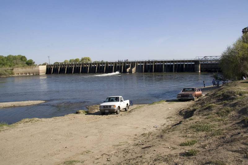
A small dam backs up the river, allowing diversion of most of the flow into the Arroyo Canal on the left.
Sack Dam Sack Dam is 5-foot-high low-head structure used to divert water from the San Joaquin River into Arroyo Canal. Diversions to Arroyo canal are usually limited to 600 cfs, but range from 0 to 800 cfs (Reclamation 2009b). Recently, changes in groundwater use are causing subsidence between the Eastside Bypass and the San Joaquin River. The San Luis Canal Company (SLCC) reports recent subsidence of Sack Dam at rates exceeding 0.5 foot per year (SLCC 2013)
Location
Other Rapids on This Run (13)
 Rapid
N/A
Rapid
N/A
Mendota Pool Dam
Rapid
N/A
Gauge below Mendota
Rapid
N/A
Firebaugh Wasteway confluence
 Rapid
N/A
Rapid
N/A
Firebaugh Park
Rapid
N/A
Gauge near Dos Palos
Rapid
N/A
Highway 152
Portage
N/A
Small Dam
Rapid
N/A
Chowchilla Bypass - Confluence
Rapid
N/A
Sandy Mush Road
Portage
N/A
Small Dam
Rapid
N/A
Highway 165 - Lander Ave
Rapid
N/A
Fremont Ford State Rec Area
Rapid
N/A
Merced River Confluence - Hills Ferry Road
View Full Run
Mendota Pool to Merced River Confluence
San Joaquin
I
86.3 mi
Portage recommended — Scout before running and consider carrying around this feature.
Current Conditions
5-Day Forecast
Whitewater data from
American Whitewater
American Whitewater