Forest Hwy.360 to White Pine (3.9 - 17 miles)
Linked via: Nhdplus discovery 90% confidence Synced 6mo ago
Gauge Conditions
Runnable: ? – ? CFS
Approximate reading: This gauge is 10.4 miles away on Big Iron. Use as a general reference only.
Data from American Whitewater & USGS
Run Map
Run Time Estimate
Select put-in and take-out to estimate time.
Unlock Advanced Trip Planning
See wind-adjusted speed maps, forecast planning, and detailed time estimates.
Sign in to generate an AI timing estimate for this run.
Whitewater timing varies with scouting, portages, and group pace. Use as a planning baseline.
Description
Quick Facts:
Location:Western Upper Peninsula, approximately 11 miles NW from Bergland.
Shuttle Length: up to 16.5 miles.
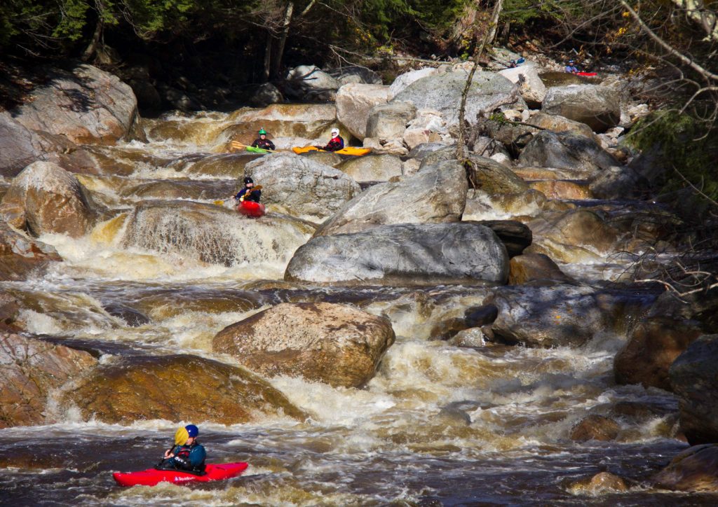
Character: Fine remote northwoods stream, with occasional canyon-like surroundings (60-80' vertical banks).
Drainage area at uppermost listed possible put-in: approximately 13 square miles.
NOTE: We are using a 'calculated' gauge ('Big Iron Approximation') based on the W.Br.Ontonagon gauge, using ratio of drainage areas. As such, it may not be accurate at all times at reflecting flow here, but should be a reasonable indication of runnability. Create a 'Trip Report' stating listed flow and your impressions (low/moderate/high), and how well gauge correlates (never/sometimes/mostly/always).
Uppermost put-in elevation is approximately 350 meters or 1148'.
Take-out elevation (after confluence with Big Iron) is approximately 760'.
Thus total elevation change is approximately 388'.
Information (lat, lng, elev, total drop, run length, shuttle length) adjusted and/or verified from best manual extrapolation of online data (via maps.google.com, distance measuring tool, and other resources). 2009.01.30
---
We are aware of some runs on some segment of the West Branch of the Big Iron River. We have no specific knowledge of put-in and take-out which have been used. The best gradient (not that any of it is that steep) is on the final stretch of the West Branch, before merging with the main Big Iron. Thus, that is the 'primary' stretch detailed here. The listed rating of class I-II(III) is highly tentative, based only upon gradient and what is observable from a 'virtual walk' via Google.
In case anyone cares or dares to explore further, we will list details and provide logistics for what seem likely upstream access points. It is unknown how possible either upper access is. Both of these upper stretches appear as though they would be potentially very scenic floats, as they appear to be in a bit of a gorge or steep valley. Again, the final ('primary') segment (as detailed in this listing) is the higher gradient reach, and has readily apparent ledge/drops.
The resolution on satellite views for this area is quite good. Go to the 'Map' tab, click 'Topo' to change to 'Satellite' and zoom in to the uppermost putin, then do a 'virtual walk' of this reach! (Reminder: The river flows North and East.)
Rapids in this Run (11)
 Rapid
Rapid
Access #1 (Uppermost Possible Putin -- S.Boundary Road/NF360)
 Rapid
Rapid
Access #2 (FDR366)
 Rapid
Rapid
Rock Garden
 Rapid
Rapid
More rock garden
 Rapid
Rapid
Rocky Island
 Rapid
Rapid
North Country Trail Bridge
 Rapid
Rapid
Confluence, Loggerhead Creek
 Rapid
Rapid
Ledge/wave/holes
 Rapid
Rapid
ledges
 Rapid
Rapid
Rocky Jumble
 Rapid
Rapid
Confluence, Big Iron
Difficulty
Class I-II(III)
Length
15.0 mi
Gradient
29 ft/mi
Rapids
11
Access Points
Shuttle Info
Access for this run (listed put-in or any of the listed 'alternate' put-ins) may be problematic.
Roads other than the main highway are not plowed in winter, so will be snow packed in early season (late winter, early spring).
Alternate routing (from that shown here by default) may be possible from the south, and should be fairly apparent from the map. Pros and cons of either route are not known at this time.
To see routing to either higher put-in (from listed put-in for lowest segment), cut-and-paste the following values into the text-entry box below:
For first higher stretch: 46.7198, -89.6945
For highest likely stretch: 46.6880, -89.7555
Difficulty Classes
I Easy
II Novice
III Intermediate
IV Advanced
V Expert/Extreme
VI Unrunnable
Current Conditions
5-Day Forecast
Whitewater data from
American Whitewater
American Whitewater